St. Sebastian geodata
St. Sebastian (Styria) is a populated place; located in Austria in Europe/Vienna (GMT+2) time zone. With population of 885 people, there are 1459 cities with bigger population in this country. Compared to other cities in Austria, 56.4% of cities are located further ↓South; 60.4% of cities are located further ←West and 88.6% of cities have lower elevation than St. Sebastian. Note1
Administrative division(s):
- Level 1: Styria
- Level 2: Politischer Bezirk Bruck-Mürzzuschlag
- Level 3: Mariazell


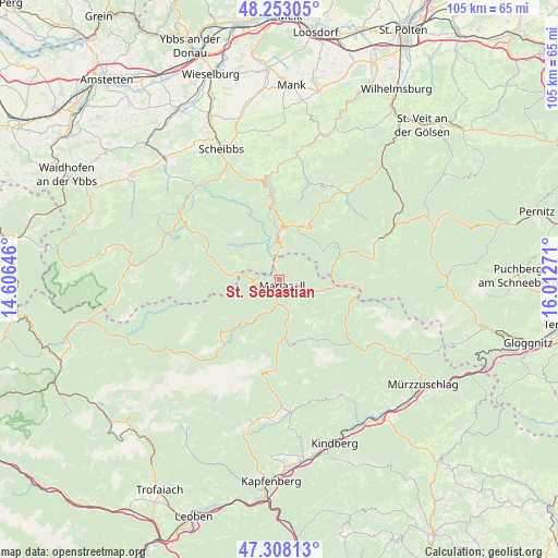
St. Sebastian GPS coordinates[2]
47° 46' 57.864" North, 15° 18' 34.488" East
| Map corner | latitude | longitude |
|---|---|---|
| Upper-left | 48.25305°, | 14.60646° |
| Center: | 47.78274°, | 15.30958° |
| Lower-right: | 47.30813°, | 16.01271° |
| Map W x H: | 105.1×105.1 km | = 65.3×65.3mi |
| max Lat: | 48.98333° ⇑43.6% North |
| St. Sebastian: | 47.78274° |
| min Lat: | ⇓56.4% South 46.48841° |
| min Long | St. Sebastian | max Long |
| 9.57802° | 15.30958° | 17.1° |
| W 60.4%⇐ | ⇒39.6% E |
Elevation
Elevation of St. Sebastian is 854 m = 2802 ft, and this is 348.5 m = 1143 ft above average elevation for this country.
| Max E: |
2140 m = 7021 ft | 11.4% |
| St. Sebastian | 854 m 2802 ft | |
| Avg. | 505.5 m = 1658 ft | |
Min E: |
118 m = 387 ft | 88.6% |
See also: Austria elevation on elevation.city.
Geographical zone
St. Sebastian is located in North temperate zone (between Tropic of Cancer and the Arctic Circle). Distance of this North polar circle is 2088.2 km =1297.5 mi to North.| Distance of | km | miles | from St. Sebastian |
|---|---|---|---|
| North Pole | 4694.1 | 2916.8 | to North |
| Arctic Circle | 2088.2 | 1297.5 | to North |
| Tropic Cancer | 2707 | 1682.1 | to South |
| Equator | 5312.9 | 3301.3 | to South |


Nearby cities:
15 places around St. Sebastian: (largest is in red/bold)
• Alpl
22.2 km =13.8 mi,  119°
119°
• Annaberg
11 km =6.8 mi,  26°
26°
• Frankenfels
22.2 km =13.8 mi,  3°
3°
• Gaming
23.2 km =14.4 mi,  314°
314°
• Gusswerk
4.6 km =2.9 mi,  183°
183°
• Loich
24.7 km =15.3 mi,  16°
16°
• Lunz am See
22.6 km =14 mi,  292°
292°
• Mariazell
1.2 km =0.7 mi,  154°
154°
• Mitterbach am Erlaufsee
3.6 km =2.2 mi,  342°
342°
• Mürzsteg
18.1 km =11.2 mi,  131°
131°
• Neuberg an der Mürz
23.7 km =14.7 mi, 123°
• Puchenstuben
16.3 km =10.1 mi,  354°
354°
• Sankt Aegyd am Neuwalde
21 km =13 mi,  67°
67°
• Schwarzenbach an der Pielach
17.6 km =10.9 mi, 18°
• Türnitz
21.4 km =13.3 mi,  39°
39°
Sources, notices
• [Note1] Compared only with cities in Austria existing in our database
• [Src1] Map data: © OpenStreetMap contributors (CC-BY-SA)
• [Src2] Other city data from geonames.org with taken over terms of usage.
• [Src3] Geographical zone / Annual Mean Temperature by Robert A. Rohde @ Wikipedia
