Mariazell geodata
Mariazell (Styria) is a seat of a third-order administrative division; located in Austria in Europe/Vienna (GMT+2) time zone. With population of 1,254 people, there are 1005 cities with bigger population in this country. Compared to other cities in Austria, 56.1% of cities are located further ↓South; 60.5% of cities are located further ←West and 89% of cities have lower elevation than Mariazell. Note1
Administrative division(s):
- Level 1: Styria
- Level 2: Politischer Bezirk Bruck-Mürzzuschlag
- Level 3: Mariazell


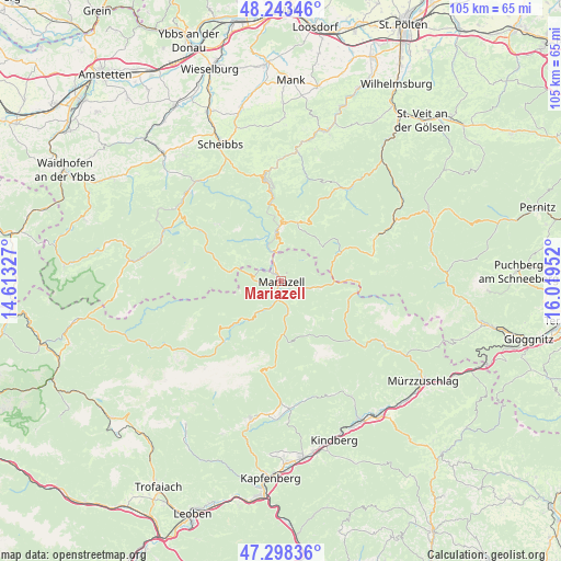
Mariazell GPS coordinates[2]
47° 46' 23.016" North, 15° 18' 59.004" East
| Map corner | latitude | longitude |
|---|---|---|
| Upper-left | 48.24346°, | 14.61327° |
| Center: | 47.77306°, | 15.31639° |
| Lower-right: | 47.29836°, | 16.01952° |
| Map W x H: | 105.1×105.1 km | = 65.3×65.3mi |
| max Lat: | 48.98333° ⇑43.9% North |
| Mariazell: | 47.77306° |
| min Lat: | ⇓56.1% South 46.48841° |
| min Long | Mariazell | max Long |
| 9.57802° | 15.31639° | 17.1° |
| W 60.5%⇐ | ⇒39.5% E |
Elevation
Elevation of Mariazell is 859 m = 2818 ft, and this is 353.5 m = 1160 ft above average elevation for this country.
| Max E: |
2140 m = 7021 ft | 11% |
| Mariazell | 859 m 2818 ft | |
| Avg. | 505.5 m = 1658 ft | |
Min E: |
118 m = 387 ft | 89% |
See also: Austria elevation on elevation.city.
Geographical zone
Mariazell is located in North temperate zone (between Tropic of Cancer and the Arctic Circle). Distance of this North polar circle is 2089.3 km =1298.2 mi to North.| Distance of | km | miles | from Mariazell |
|---|---|---|---|
| North Pole | 4695.2 | 2917.5 | to North |
| Arctic Circle | 2089.3 | 1298.2 | to North |
| Tropic Cancer | 2705.9 | 1681.4 | to South |
| Equator | 5311.9 | 3300.7 | to South |


Nearby cities:
15 places around Mariazell: (largest is in red/bold)
• Alpl
21.2 km =13.2 mi,  118°
118°
• Annaberg
11.8 km =7.3 mi,  22°
22°
• Frankenfels
23.3 km =14.5 mi,  1°
1°
• Grossveitsch
23.6 km =14.7 mi,  150°
150°
• Gusswerk
3.6 km =2.2 mi,  193°
193°
• Lunz am See
23.5 km =14.6 mi,  294°
294°
• Mitterbach am Erlaufsee
4.8 km =3 mi,  340°
340°
• Mürzsteg
17 km =10.6 mi,  129°
129°
• Neuberg an der Mürz
22.6 km =14 mi, 122°
• Puchenstuben
17.4 km =10.8 mi,  352°
352°
• Sankt Aegyd am Neuwalde
20.9 km =13 mi,  64°
64°
• Schwarzenbach an der Pielach
18.5 km =11.5 mi, 15°
• St. Sebastian
1.2 km =0.7 mi,  334°
334°
• Turnau
24 km =14.9 mi,  176°
176°
• Türnitz
21.9 km =13.6 mi,  36°
36°
Sources, notices
• [Note1] Compared only with cities in Austria existing in our database
• [Src1] Map data: © OpenStreetMap contributors (CC-BY-SA)
• [Src2] Other city data from geonames.org with taken over terms of usage.
• [Src3] Geographical zone / Annual Mean Temperature by Robert A. Rohde @ Wikipedia
