Großrußbach geodata
Großrußbach (Lower Austria) is a seat of a third-order administrative division; located in Austria in Europe/Vienna (GMT+2) time zone. With population of 895 people, there are 1442 cities with bigger population in this country. Compared to other cities in Austria, 93.6% of cities are located further ↓South; 91.7% of cities are located further ←West and 81.2% of cities have higher elevation than Großrußbach. Note1
Administrative division(s):
- Level 1: Lower Austria
- Level 2: Politischer Bezirk Korneuburg
- Level 3: Großrußbach


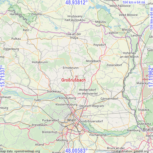
Großrußbach GPS coordinates[2]
48° 28' 26.832" North, 16° 24' 59.364" East
| Map corner | latitude | longitude |
|---|---|---|
| Upper-left | 48.93812°, | 15.71337° |
| Center: | 48.47412°, | 16.41649° |
| Lower-right: | 48.00583°, | 17.11962° |
| Map W x H: | 103.7×103.7 km | = 64.4×64.4mi |
| max Lat: | 48.98333° ⇑6.4% North |
| Großrußbach: | 48.47412° |
| min Lat: | ⇓93.6% South 46.48841° |
| min Long | Großrußbach | max Long |
| 9.57802° | 16.41649° | 17.1° |
| W 91.7%⇐ | ⇒8.3% E |
Elevation
Elevation of Großrußbach is 269 m = 883 ft, and this is 236.5 m = 776 ft below average elevation for this country.
| Max E: |
2140 m = 7021 ft | 81.2% |
| Avg. | 505.5 m = 1658 ft | |
| Großrußbach | 269 m = 883 ft | |
Min E: |
118 m = 387 ft | 18.8% |
See also: Austria elevation on elevation.city.
Geographical zone
Großrußbach is located in North temperate zone (between Tropic of Cancer and the Arctic Circle). Distance of this North polar circle is 2011.4 km =1249.8 mi to North.| Distance of | km | miles | from Großrußbach |
|---|---|---|---|
| North Pole | 4617.2 | 2869 | to North |
| Arctic Circle | 2011.4 | 1249.8 | to North |
| Tropic Cancer | 2783.9 | 1729.8 | to South |
| Equator | 5389.8 | 3349.1 | to South |


Nearby cities:
15 places around Großrußbach: (largest is in red/bold)
• Ernstbrunn
8.2 km =5.1 mi,  323°
323°
• Harmannsdorf
9.2 km =5.7 mi,  200°
200°
• Hautzendorf
6.7 km =4.2 mi,  132°
132°
• Hochleithen
8.8 km =5.5 mi,  105°
105°
• Kreuzstetten
4.2 km =2.6 mi,  80°
80°
• Ladendorf
8.2 km =5.1 mi,  36°
36°
• Niederkreuzstetten
4.5 km =2.8 mi,  85°
85°
• Niederleis
8.5 km =5.3 mi,  351°
351°
• Obergänserndorf
7.4 km =4.6 mi,  209°
209°
• Rückersdorf
9.7 km =6 mi, 200°
• Schleinbach
7.4 km =4.6 mi,  149°
149°
• Ulrichskirchen
9.6 km =6 mi, 149°
• Unterolberndorf
6.7 km =4.2 mi, 132°
• Wolfpassing an der Hochleithen
7.9 km =4.9 mi, 109°
• Würnitz
6.4 km =4 mi,  179°
179°
Sources, notices
• [Note1] Compared only with cities in Austria existing in our database
• [Src1] Map data: © OpenStreetMap contributors (CC-BY-SA)
• [Src2] Other city data from geonames.org with taken over terms of usage.
• [Src3] Geographical zone / Annual Mean Temperature by Robert A. Rohde @ Wikipedia
