Salzburg geodata
Salzburg is a seat of a first-order administrative division; located in Austria in Europe/Vienna (GMT+2) time zone. With population of 153,377 people, there are 6 cities with bigger population in this country. Compared to other cities in Austria, 57% of cities are located further ↓South; 82.4% of cities are located further →East and 53% of cities have higher elevation than Salzburg. Note1


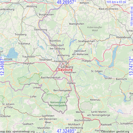
Salzburg GPS coordinates[2]
47° 47' 57.876" North, 13° 2' 38.364" East
| Map corner | latitude | longitude |
|---|---|---|
| Upper-left | 48.26957°, | 12.34087° |
| Center: | 47.79941°, | 13.04399° |
| Lower-right: | 47.32495°, | 13.74712° |
| Map W x H: | 105×105 km | = 65.2×65.2mi |
| max Lat: | 48.98333° ⇑43% North |
| Salzburg: | 47.79941° |
| min Lat: | ⇓57% South 46.48841° |
| min Long | Salzburg | max Long |
| 9.57802° | 13.04399° | 17.1° |
| W 17.6%⇐ | ⇒82.4% E |
Elevation
Elevation of Salzburg is 435 m = 1427 ft, and this is 70.5 m = 231 ft below average elevation for this country.
| Max E: |
2140 m = 7021 ft | 53% |
| Avg. | 505.5 m = 1658 ft | |
| Salzburg | 435 m = 1427 ft | |
Min E: |
118 m = 387 ft | 47% |
See also: Salzburg elevation on elevation.city.
Geographical zone
Salzburg is located in North temperate zone (between Tropic of Cancer and the Arctic Circle). Distance of this North polar circle is 2086.4 km =1296.4 mi to North.| Distance of | km | miles | from Salzburg |
|---|---|---|---|
| North Pole | 4692.3 | 2915.7 | to North |
| Arctic Circle | 2086.4 | 1296.4 | to North |
| Tropic Cancer | 2708.9 | 1683.2 | to South |
| Equator | 5314.8 | 3302.5 | to South |


Nearby cities:
15 places around Salzburg: (largest is in red/bold)
• Anif
5.7 km =3.5 mi,  162°
162°
• Bergheim
3.9 km =2.4 mi,  348°
348°
• Elsbethen
4.8 km =3 mi,  144°
144°
• Esch
5.8 km =3.6 mi,  38°
38°
• Glanegg
6.4 km =4 mi,  210°
210°
• Glasenbach
4.7 km =2.9 mi, 141°
• Gois
6.8 km =4.2 mi,  237°
237°
• Grödig
6.8 km =4.2 mi,  184°
184°
• Hallwang
6.3 km =3.9 mi,  27°
27°
• Himmelreich
4.5 km =2.8 mi,  270°
270°
• Lengfelden
5.6 km =3.5 mi,  4°
4°
• Siezenheim
4.4 km =2.7 mi,  293°
293°
• Viehhausen
4.9 km =3 mi,  248°
248°
• Wals
6 km =3.7 mi, 252°
• Walserfeld
4.8 km =3 mi,  260°
260°
In other languages:
- In Spanish: Salzburgo
- In France: Salzbourg
- In Italian: Salisburgo
- In Russian: Зальцбург
- In Chinese: 萨尔斯堡, 薩爾斯堡, 萨尔茨堡
Sources, notices
• [Note1] Compared only with cities in Austria existing in our database
• [Src1] Map data: © OpenStreetMap contributors (CC-BY-SA)
• [Src2] Other city data from geonames.org with taken over terms of usage.
• [Src3] Geographical zone / Annual Mean Temperature by Robert A. Rohde @ Wikipedia
