Thal geodata
Thal (Styria) is a seat of a third-order administrative division; located in Austria in Europe/Vienna (GMT+2) time zone. With population of 2,261 people, there are 537 cities with bigger population in this country. Compared to other cities in Austria, 80.5% of cities are located further ↑North; 61.8% of cities are located further ←West and 50.2% of cities have lower elevation than Thal. Note1


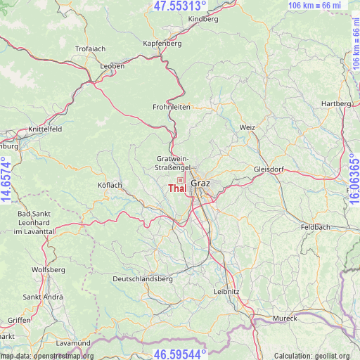
Thal GPS coordinates[2]
47° 4' 35.184" North, 15° 21' 37.872" East
| Map corner | latitude | longitude |
|---|---|---|
| Upper-left | 47.55313°, | 14.6574° |
| Center: | 47.07644°, | 15.36052° |
| Lower-right: | 46.59544°, | 16.06365° |
| Map W x H: | 106.5×106.5 km | = 66.2×66.2mi |
| max Lat: | 48.98333° ⇑80.5% North |
| Thal: | 47.07644° |
| min Lat: | ⇓19.5% South 46.48841° |
| min Long | Thal | max Long |
| 9.57802° | 15.36052° | 17.1° |
| W 61.8%⇐ | ⇒38.2% E |
Elevation
Elevation of Thal is 451 m = 1480 ft, and this is 54.5 m = 179 ft below average elevation for this country.
| Max E: |
2140 m = 7021 ft | 49.8% |
| Avg. | 505.5 m = 1658 ft | |
| Thal | 451 m = 1480 ft | |
Min E: |
118 m = 387 ft | 50.2% |
See also: Austria elevation on elevation.city.
Geographical zone
Thal is located in North temperate zone (between Tropic of Cancer and the Arctic Circle). Distance of this North polar circle is 2166.8 km =1346.4 mi to North.| Distance of | km | miles | from Thal |
|---|---|---|---|
| North Pole | 4772.7 | 2965.6 | to North |
| Arctic Circle | 2166.8 | 1346.4 | to North |
| Tropic Cancer | 2628.5 | 1633.3 | to South |
| Equator | 5234.4 | 3252.5 | to South |


Nearby cities:
15 places around Thal: (largest is in red/bold)
• Andritz
6.3 km =3.9 mi,  48°
48°
• Eggenberg
3 km =1.9 mi,  103°
103°
• Gratwein
5.6 km =3.5 mi,  323°
323°
• Gries
5.1 km =3.2 mi,  107°
107°
• Gösting
3.7 km =2.3 mi, 49°
• Innere Stadt
6.2 km =3.9 mi, 100°
• Judendorf
4.5 km =2.8 mi,  349°
349°
• Kirchenviertel
6.2 km =3.9 mi, 350°
• Lend
4.2 km =2.6 mi,  80°
80°
• Plankenwarth
4 km =2.5 mi,  291°
291°
• Rötz
5.6 km =3.5 mi, 323°
• Steinberg
3.5 km =2.2 mi,  251°
251°
• Strassengel
4.8 km =3 mi,  334°
334°
• Straßgang
5.6 km =3.5 mi,  148°
148°
• Wetzelsdorf
3.9 km =2.4 mi,  131°
131°
Sources, notices
• [Note1] Compared only with cities in Austria existing in our database
• [Src1] Map data: © OpenStreetMap contributors (CC-BY-SA)
• [Src2] Other city data from geonames.org with taken over terms of usage.
• [Src3] Geographical zone / Annual Mean Temperature by Robert A. Rohde @ Wikipedia
