Gnesau geodata
Gnesau (Carinthia) is a seat of a third-order administrative division; located in Austria in Europe/Vienna (GMT+2) time zone. With population of 353 people, there are 2681 cities with bigger population in this country. Compared to other cities in Austria, 92.5% of cities are located further ↑North; 65.7% of cities are located further →East and 93.5% of cities have lower elevation than Gnesau. Note1
Administrative division(s):
- Level 1: Carinthia
- Level 2: Politischer Bezirk Feldkirchen
- Level 3: Gnesau


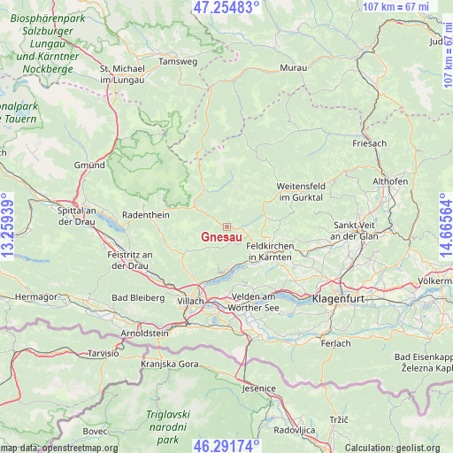
Gnesau GPS coordinates[2]
46° 46' 31.584" North, 13° 57' 45.036" East
| Map corner | latitude | longitude |
|---|---|---|
| Upper-left | 47.25483°, | 13.25939° |
| Center: | 46.77544°, | 13.96251° |
| Lower-right: | 46.29174°, | 14.66564° |
| Map W x H: | 107.1×107.1 km | = 66.5×66.5mi |
| max Lat: | 48.98333° ⇑92.5% North |
| Gnesau: | 46.77544° |
| min Lat: | ⇓7.5% South 46.48841° |
| min Long | Gnesau | max Long |
| 9.57802° | 13.96251° | 17.1° |
| W 34.3%⇐ | ⇒65.7% E |
Elevation
Elevation of Gnesau is 973 m = 3192 ft, and this is 467.5 m = 1534 ft above average elevation for this country.
| Max E: |
2140 m = 7021 ft | 6.5% |
| Gnesau | 973 m 3192 ft | |
| Avg. | 505.5 m = 1658 ft | |
Min E: |
118 m = 387 ft | 93.5% |
See also: Austria elevation on elevation.city.
Geographical zone
Gnesau is located in North temperate zone (between Tropic of Cancer and the Arctic Circle). Distance of this North polar circle is 2200.2 km =1367.1 mi to North.| Distance of | km | miles | from Gnesau |
|---|---|---|---|
| North Pole | 4806.1 | 2986.4 | to North |
| Arctic Circle | 2200.2 | 1367.1 | to North |
| Tropic Cancer | 2595 | 1612.5 | to South |
| Equator | 5200.9 | 3231.7 | to South |


Nearby cities:
15 places around Gnesau: (largest is in red/bold)
• Arriach
10 km =6.2 mi,  238°
238°
• Bodensdorf
9.4 km =5.8 mi,  176°
176°
• Draschen
8 km =5 mi,  95°
95°
• Feldkirchen in Kärnten
11.7 km =7.3 mi,  119°
119°
• Fresen
10 km =6.2 mi,  141°
141°
• Himmelberg
5.6 km =3.5 mi,  111°
111°
• Lindl
12.1 km =7.5 mi, 123°
• Ossiach
11.4 km =7.1 mi,  171°
171°
• Sankt Ruprecht
11.9 km =7.4 mi, 115°
• Sankt Ulrich
12.1 km =7.5 mi, 103°
• Seitenberg
10.1 km =6.3 mi, 107°
• Steindorf am Ossiacher See
9.3 km =5.8 mi,  157°
157°
• Steuerberg
11.5 km =7.1 mi,  83°
83°
• Tschöran
10.7 km =6.6 mi, 180°
• Waiern
10.4 km =6.5 mi, 118°
Sources, notices
• [Note1] Compared only with cities in Austria existing in our database
• [Src1] Map data: © OpenStreetMap contributors (CC-BY-SA)
• [Src2] Other city data from geonames.org with taken over terms of usage.
• [Src3] Geographical zone / Annual Mean Temperature by Robert A. Rohde @ Wikipedia
