Eberndorf geodata
Eberndorf (Carinthia) is a seat of a third-order administrative division; located in Austria in Europe/Vienna (GMT+2) time zone. With population of 1,124 people, there are 1132 cities with bigger population in this country. Compared to other cities in Austria, 98.9% of cities are located further ↑North; 51% of cities are located further →East and 55.2% of cities have lower elevation than Eberndorf. Note1
Administrative division(s):
- Level 1: Carinthia
- Level 2: Politischer Bezirk Völkermarkt
- Level 3: Eberndorf


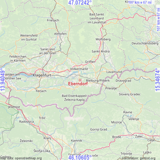
Eberndorf GPS coordinates[2]
46° 35' 29.004" North, 14° 38' 36.996" East
| Map corner | latitude | longitude |
|---|---|---|
| Upper-left | 47.07242°, | 13.94049° |
| Center: | 46.59139°, | 14.64361° |
| Lower-right: | 46.10605°, | 15.34674° |
| Map W x H: | 107.5×107.4 km | = 66.8×66.7mi |
| max Lat: | 48.98333° ⇑98.9% North |
| Eberndorf: | 46.59139° |
| min Lat: | ⇓1.1% South 46.48841° |
| min Long | Eberndorf | max Long |
| 9.57802° | 14.64361° | 17.1° |
| W 49%⇐ | ⇒51% E |
Elevation
Elevation of Eberndorf is 486 m = 1594 ft, and this is 19.5 m = 64 ft below average elevation for this country.
| Max E: |
2140 m = 7021 ft | 44.8% |
| Avg. | 505.5 m = 1658 ft | |
| Eberndorf | 486 m = 1594 ft | |
Min E: |
118 m = 387 ft | 55.2% |
See also: Austria elevation on elevation.city.
Geographical zone
Eberndorf is located in North temperate zone (between Tropic of Cancer and the Arctic Circle). Distance of this North polar circle is 2220.7 km =1379.9 mi to North.| Distance of | km | miles | from Eberndorf |
|---|---|---|---|
| North Pole | 4826.6 | 2999.1 | to North |
| Arctic Circle | 2220.7 | 1379.9 | to North |
| Tropic Cancer | 2574.6 | 1599.8 | to South |
| Equator | 5180.5 | 3219 | to South |


Nearby cities:
15 places around Eberndorf: (largest is in red/bold)
• Bad Eisenkappel
12.1 km =7.5 mi,  199°
199°
• Bleiburg/Pliberk
11.9 km =7.4 mi,  90°
90°
• Ebersdorf
10.7 km =6.6 mi, 94°
• Feistritz ob Bleiburg
10.5 km =6.5 mi,  116°
116°
• Gallizien
10.7 km =6.6 mi,  244°
244°
• Globasnitz
5.9 km =3.7 mi,  130°
130°
• Gösselsdorf
2.1 km =1.3 mi, 197°
• Kühnsdorf
3.4 km =2.1 mi,  350°
350°
• Mittlern
6.2 km =3.9 mi,  76°
76°
• Ruden
12.6 km =7.8 mi,  53°
53°
• Sankt Michael ob Bleiburg
7.7 km =4.8 mi,  100°
100°
• Sittersdorf
6 km =3.7 mi,  208°
208°
• Tainach
9.6 km =6 mi,  298°
298°
• Völkermarkt
7.9 km =4.9 mi, 354°
• Wasserhofen
3.5 km =2.2 mi,  323°
323°
Sources, notices
• [Note1] Compared only with cities in Austria existing in our database
• [Src1] Map data: © OpenStreetMap contributors (CC-BY-SA)
• [Src2] Other city data from geonames.org with taken over terms of usage.
• [Src3] Geographical zone / Annual Mean Temperature by Robert A. Rohde @ Wikipedia
