Dürnstein geodata
Dürnstein (Lower Austria) is a seat of a third-order administrative division; located in Austria in Europe/Vienna (GMT+2) time zone. With population of 322 people, there are 2716 cities with bigger population in this country. Compared to other cities in Austria, 90.5% of cities are located further ↓South; 66.3% of cities are located further ←West and 88.8% of cities have higher elevation than Dürnstein. Note1
Administrative division(s):
- Level 1: Lower Austria
- Level 2: Politischer Bezirk Krems
- Level 3: Dürnstein


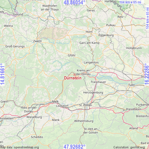
Dürnstein GPS coordinates[2]
48° 23' 44.952" North, 15° 31' 11.028" East
| Map corner | latitude | longitude |
|---|---|---|
| Upper-left | 48.86054°, | 14.81661° |
| Center: | 48.39582°, | 15.51973° |
| Lower-right: | 47.92682°, | 16.22286° |
| Map W x H: | 103.8×103.8 km | = 64.5×64.5mi |
| max Lat: | 48.98333° ⇑9.5% North |
| Dürnstein: | 48.39582° |
| min Lat: | ⇓90.5% South 46.48841° |
| min Long | Dürnstein | max Long |
| 9.57802° | 15.51973° | 17.1° |
| W 66.3%⇐ | ⇒33.7% E |
Elevation
Elevation of Dürnstein is 223 m = 732 ft, and this is 282.5 m = 927 ft below average elevation for this country.
| Max E: |
2140 m = 7021 ft | 88.8% |
| Avg. | 505.5 m = 1658 ft | |
| Dürnstein | 223 m = 732 ft | |
Min E: |
118 m = 387 ft | 11.2% |
See also: Austria elevation on elevation.city.
Geographical zone
Dürnstein is located in North temperate zone (between Tropic of Cancer and the Arctic Circle). Distance of this North polar circle is 2020.1 km =1255.2 mi to North.| Distance of | km | miles | from Dürnstein |
|---|---|---|---|
| North Pole | 4626 | 2874.5 | to North |
| Arctic Circle | 2020.1 | 1255.2 | to North |
| Tropic Cancer | 2775.2 | 1724.4 | to South |
| Equator | 5381.1 | 3343.7 | to South |


Nearby cities:
15 places around Dürnstein: (largest is in red/bold)
• Egelsee
4 km =2.5 mi,  52°
52°
• Furth bei Göttweig
7.4 km =4.6 mi,  109°
109°
• Imbach
7.6 km =4.7 mi,  37°
37°
• Krems an der Donau
7.1 km =4.4 mi,  77°
77°
• Lerchenfeld
8.5 km =5.3 mi, 77°
• Mautern
4.3 km =2.7 mi,  93°
93°
• Palt
7.1 km =4.4 mi,  100°
100°
• Rehberg
6.3 km =3.9 mi, 51°
• Senftenberg
4.7 km =2.9 mi,  28°
28°
• Stein an der Donau
4.6 km =2.9 mi, 81°
• Stratzing
8.4 km =5.2 mi, 44°
• Unterbergern
3.9 km =2.4 mi,  145°
145°
• Weinzierl am Walde
7.6 km =4.7 mi,  301°
301°
• Weinzierl bei Krems
5.9 km =3.7 mi, 85°
• Weißenkirchen in der Wachau
3.7 km =2.3 mi,  273°
273°
Sources, notices
• [Note1] Compared only with cities in Austria existing in our database
• [Src1] Map data: © OpenStreetMap contributors (CC-BY-SA)
• [Src2] Other city data from geonames.org with taken over terms of usage.
• [Src3] Geographical zone / Annual Mean Temperature by Robert A. Rohde @ Wikipedia
