Burgfried geodata
Burgfried (Upper Austria) is a populated place; located in Austria in Europe/Vienna (GMT+2) time zone. With population of 2,075 people, there are 587 cities with bigger population in this country. Compared to other cities in Austria, 94.7% of cities are located further ↓South; 57.9% of cities are located further →East and 81.5% of cities have lower elevation than Burgfried. Note1
Administrative division(s):
- Level 1: Upper Austria
- Level 2: Politischer Bezirk Urfahr-Umgebung
- Level 3: Bad Leonfelden


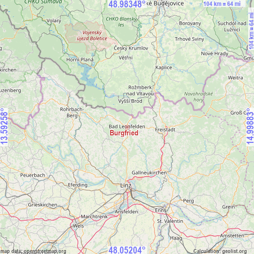
Burgfried GPS coordinates[2]
48° 31' 11.64" North, 14° 17' 44.52" East
| Map corner | latitude | longitude |
|---|---|---|
| Upper-left | 48.98348°, | 13.59258° |
| Center: | 48.5199°, | 14.2957° |
| Lower-right: | 48.05204°, | 14.99883° |
| Map W x H: | 103.6×103.6 km | = 64.4×64.4mi |
| max Lat: | 48.98333° ⇑5.3% North |
| Burgfried: | 48.5199° |
| min Lat: | ⇓94.7% South 46.48841° |
| min Long | Burgfried | max Long |
| 9.57802° | 14.2957° | 17.1° |
| W 42.1%⇐ | ⇒57.9% E |
Elevation
Elevation of Burgfried is 744 m = 2441 ft, and this is 238.5 m = 782 ft above average elevation for this country.
| Max E: |
2140 m = 7021 ft | 18.5% |
| Burgfried | 744 m 2441 ft | |
| Avg. | 505.5 m = 1658 ft | |
Min E: |
118 m = 387 ft | 81.5% |
See also: Austria elevation on elevation.city.
Geographical zone
Burgfried is located in North temperate zone (between Tropic of Cancer and the Arctic Circle). Distance of this North polar circle is 2006.3 km =1246.7 mi to North.| Distance of | km | miles | from Burgfried |
|---|---|---|---|
| North Pole | 4612.2 | 2865.9 | to North |
| Arctic Circle | 2006.3 | 1246.7 | to North |
| Tropic Cancer | 2789 | 1733 | to South |
| Equator | 5394.9 | 3352.2 | to South |


Nearby cities:
15 places around Burgfried: (largest is in red/bold)
• Ahorn
9 km =5.6 mi,  272°
272°
• Bad Leonfelden
0.1 km =0.1 mi,  307°
307°
• Haibach im Mühlkreis
9.1 km =5.7 mi,  157°
157°
• Hellmonsödt
9.6 km =6 mi,  178°
178°
• Kirchschlag bei Linz
12.1 km =7.5 mi,  186°
186°
• Oberneukirchen
8.2 km =5.1 mi,  220°
220°
• Ottenschlag im Mühlkreis
8.9 km =5.5 mi,  132°
132°
• Reichenau im Mühlkreis
8 km =5 mi,  150°
150°
• Reichenthal
7 km =4.3 mi,  68°
68°
• Sankt Veit im Mühlkreis
11.3 km =7 mi,  239°
239°
• Schenkenfelden
5.2 km =3.2 mi,  111°
111°
• Sonnberg im Mühlkreis
6.7 km =4.2 mi,  169°
169°
• Summerau
11.3 km =7 mi, 71°
• Vorderweissenbach
6.8 km =4.2 mi,  301°
301°
• Zwettl an der Rodl
6.3 km =3.9 mi,  196°
196°
Sources, notices
• [Note1] Compared only with cities in Austria existing in our database
• [Src1] Map data: © OpenStreetMap contributors (CC-BY-SA)
• [Src2] Other city data from geonames.org with taken over terms of usage.
• [Src3] Geographical zone / Annual Mean Temperature by Robert A. Rohde @ Wikipedia
