Burgau geodata
Burgau (Styria) is a seat of a third-order administrative division; located in Austria in Europe/Vienna (GMT+2) time zone. With population of 1,040 people, there are 1230 cities with bigger population in this country. Compared to other cities in Austria, 76.4% of cities are located further ↑North; 82.7% of cities are located further ←West and 78.5% of cities have higher elevation than Burgau. Note1
Administrative division(s):
- Level 1: Styria
- Level 2: Politischer Bezirk Hartberg-Fürstenfeld
- Level 3: Burgau


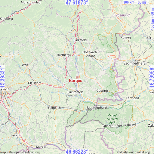
Burgau GPS coordinates[2]
47° 8' 33.648" North, 16° 5' 47.148" East
| Map corner | latitude | longitude |
|---|---|---|
| Upper-left | 47.61878°, | 15.39331° |
| Center: | 47.14268°, | 16.09643° |
| Lower-right: | 46.66228°, | 16.79956° |
| Map W x H: | 106.4×106.4 km | = 66.1×66.1mi |
| max Lat: | 48.98333° ⇑76.4% North |
| Burgau: | 47.14268° |
| min Lat: | ⇓23.6% South 46.48841° |
| min Long | Burgau | max Long |
| 9.57802° | 16.09643° | 17.1° |
| W 82.7%⇐ | ⇒17.3% E |
Elevation
Elevation of Burgau is 281 m = 922 ft, and this is 224.5 m = 737 ft below average elevation for this country.
| Max E: |
2140 m = 7021 ft | 78.5% |
| Avg. | 505.5 m = 1658 ft | |
| Burgau | 281 m = 922 ft | |
Min E: |
118 m = 387 ft | 21.5% |
See also: Austria elevation on elevation.city.
Geographical zone
Burgau is located in North temperate zone (between Tropic of Cancer and the Arctic Circle). Distance of this North polar circle is 2159.4 km =1341.8 mi to North.| Distance of | km | miles | from Burgau |
|---|---|---|---|
| North Pole | 4765.3 | 2961 | to North |
| Arctic Circle | 2159.4 | 1341.8 | to North |
| Tropic Cancer | 2635.9 | 1637.9 | to South |
| Equator | 5241.8 | 3257.1 | to South |


Nearby cities:
15 places around Burgau: (largest is in red/bold)
• Bad Blumau
4.5 km =2.8 mi,  230°
230°
• Bad Waltersdorf
7.3 km =4.5 mi,  294°
294°
• Bocksdorf
6.2 km =3.9 mi,  90°
90°
• Burgauberg
2.1 km =1.3 mi,  74°
74°
• Deutsch Kaltenbrunn
6 km =3.7 mi,  153°
153°
• Hackerberg
6.6 km =4.1 mi,  13°
13°
• Heugraben
7.6 km =4.7 mi,  111°
111°
• Leitersdorf bei Hartberg
4.8 km =3 mi,  279°
279°
• Neudau
3.7 km =2.3 mi, 6°
• Neudauberg
3.7 km =2.3 mi,  28°
28°
• Ollersdorf im Burgenland
7 km =4.3 mi,  49°
49°
• Rohr im Burgenland
6 km =3.7 mi,  118°
118°
• Rohrbrunn
2.5 km =1.6 mi, 145°
• Stegersbach
5.9 km =3.7 mi,  63°
63°
• Stinatz
7.2 km =4.5 mi,  22°
22°
Sources, notices
• [Note1] Compared only with cities in Austria existing in our database
• [Src1] Map data: © OpenStreetMap contributors (CC-BY-SA)
• [Src2] Other city data from geonames.org with taken over terms of usage.
• [Src3] Geographical zone / Annual Mean Temperature by Robert A. Rohde @ Wikipedia
