Burgauberg geodata
Burgauberg (Burgenland) is a populated place; located in Austria in Europe/Vienna (GMT+2) time zone. With population of 773 people, there are 1668 cities with bigger population in this country. Compared to other cities in Austria, 76.1% of cities are located further ↑North; 84% of cities are located further ←West and 68.6% of cities have higher elevation than Burgauberg. Note1
Administrative division(s):
- Level 1: Burgenland
- Level 2: Politischer Bezirk Güssing
- Level 3: Burgauberg-Neudauberg


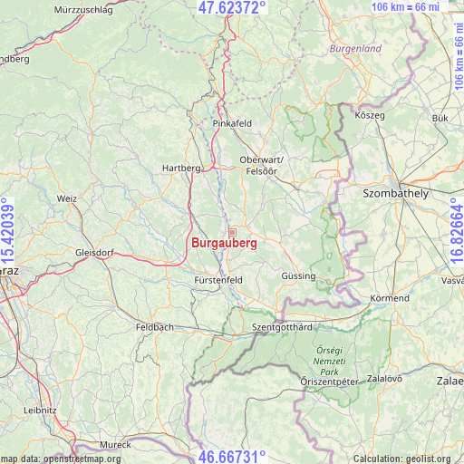
Burgauberg GPS coordinates[2]
47° 8' 51.612" North, 16° 7' 24.636" East
| Map corner | latitude | longitude |
|---|---|---|
| Upper-left | 47.62372°, | 15.42039° |
| Center: | 47.14767°, | 16.12351° |
| Lower-right: | 46.66731°, | 16.82664° |
| Map W x H: | 106.3×106.3 km | = 66.1×66.1mi |
| max Lat: | 48.98333° ⇑76.1% North |
| Burgauberg: | 47.14767° |
| min Lat: | ⇓23.9% South 46.48841° |
| min Long | Burgauberg | max Long |
| 9.57802° | 16.12351° | 17.1° |
| W 84%⇐ | ⇒16% E |
Elevation
Elevation of Burgauberg is 336 m = 1102 ft, and this is 169.5 m = 556 ft below average elevation for this country.
| Max E: |
2140 m = 7021 ft | 68.6% |
| Avg. | 505.5 m = 1658 ft | |
| Burgauberg | 336 m = 1102 ft | |
Min E: |
118 m = 387 ft | 31.4% |
See also: Austria elevation on elevation.city.
Geographical zone
Burgauberg is located in North temperate zone (between Tropic of Cancer and the Arctic Circle). Distance of this North polar circle is 2158.8 km =1341.4 mi to North.| Distance of | km | miles | from Burgauberg |
|---|---|---|---|
| North Pole | 4764.7 | 2960.6 | to North |
| Arctic Circle | 2158.8 | 1341.4 | to North |
| Tropic Cancer | 2636.4 | 1638.2 | to South |
| Equator | 5242.3 | 3257.4 | to South |


Nearby cities:
15 places around Burgauberg: (largest is in red/bold)
• Bad Blumau
6.5 km =4 mi,  238°
238°
• Bocksdorf
4.1 km =2.5 mi,  97°
97°
• Burgau
2.1 km =1.3 mi,  254°
254°
• Deutsch Kaltenbrunn
5.9 km =3.7 mi,  174°
174°
• Hackerberg
5.8 km =3.6 mi,  354°
354°
• Heugraben
6.1 km =3.8 mi,  123°
123°
• Leitersdorf bei Hartberg
6.8 km =4.2 mi,  272°
272°
• Neudau
3.5 km =2.2 mi,  332°
332°
• Neudauberg
2.7 km =1.7 mi, 353°
• Olbendorf
7 km =4.3 mi,  55°
55°
• Ollersdorf im Burgenland
5.1 km =3.2 mi,  39°
39°
• Rohr im Burgenland
4.7 km =2.9 mi,  136°
136°
• Rohrbrunn
2.7 km =1.7 mi,  193°
193°
• Stegersbach
3.9 km =2.4 mi, 57°
• Stinatz
6.2 km =3.9 mi,  6°
6°
Sources, notices
• [Note1] Compared only with cities in Austria existing in our database
• [Src1] Map data: © OpenStreetMap contributors (CC-BY-SA)
• [Src2] Other city data from geonames.org with taken over terms of usage.
• [Src3] Geographical zone / Annual Mean Temperature by Robert A. Rohde @ Wikipedia
