Absam geodata
Absam (Tyrol) is a seat of a third-order administrative division; located in Austria in Europe/Vienna (GMT+2) time zone. With population of 7,112 people, there are 130 cities with bigger population in this country. Compared to other cities in Austria, 65.8% of cities are located further ↑North; 91.3% of cities are located further →East and 75% of cities have lower elevation than Absam. Note1
Administrative division(s):
- Level 1: Tyrol
- Level 2: Politischer Bezirk Innsbruck Land
- Level 3: Absam


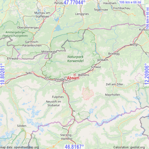
Absam GPS coordinates[2]
47° 17' 44.592" North, 11° 30' 21.348" East
| Map corner | latitude | longitude |
|---|---|---|
| Upper-left | 47.77044°, | 10.80281° |
| Center: | 47.29572°, | 11.50593° |
| Lower-right: | 46.8167°, | 12.20906° |
| Map W x H: | 106×106 km | = 65.9×65.9mi |
| max Lat: | 48.98333° ⇑65.8% North |
| Absam: | 47.29572° |
| min Lat: | ⇓34.2% South 46.48841° |
| min Long | Absam | max Long |
| 9.57802° | 11.50593° | 17.1° |
| W 8.7%⇐ | ⇒91.3% E |
Elevation
Elevation of Absam is 650 m = 2133 ft, and this is 144.5 m = 474 ft above average elevation for this country.
| Max E: |
2140 m = 7021 ft | 25% |
| Absam | 650 m 2133 ft | |
| Avg. | 505.5 m = 1658 ft | |
Min E: |
118 m = 387 ft | 75% |
See also: Austria elevation on elevation.city.
Geographical zone
Absam is located in North temperate zone (between Tropic of Cancer and the Arctic Circle). Distance of this North polar circle is 2142.4 km =1331.2 mi to North.| Distance of | km | miles | from Absam |
|---|---|---|---|
| North Pole | 4748.3 | 2950.5 | to North |
| Arctic Circle | 2142.4 | 1331.2 | to North |
| Tropic Cancer | 2652.9 | 1648.4 | to South |
| Equator | 5258.8 | 3267.7 | to South |


Nearby cities:
15 places around Absam: (largest is in red/bold)
• Aldrans
6.6 km =4.1 mi,  219°
219°
• Ampass
4.9 km =3 mi, 221°
• Arzl
5.6 km =3.5 mi,  255°
255°
• Baumkirchen
4.6 km =2.9 mi,  84°
84°
• Fritzens
6.4 km =4 mi, 80°
• Gnadenwald
5.1 km =3.2 mi,  63°
63°
• Hall in Tirol
1.6 km =1 mi,  149°
149°
• Heiligkreuz
1.4 km =0.9 mi, 220°
• Mils bei Solbad Hall
2.5 km =1.6 mi,  123°
123°
• Rinn
5.1 km =3.2 mi,  185°
185°
• Rum
4.4 km =2.7 mi,  251°
251°
• Thaur
2.3 km =1.4 mi,  267°
267°
• Tulfes
4.7 km =2.9 mi, 153°
• Volders
4.8 km =3 mi,  106°
106°
• Wattens
6.4 km =4 mi,  91°
91°
Sources, notices
• [Note1] Compared only with cities in Austria existing in our database
• [Src1] Map data: © OpenStreetMap contributors (CC-BY-SA)
• [Src2] Other city data from geonames.org with taken over terms of usage.
• [Src3] Geographical zone / Annual Mean Temperature by Robert A. Rohde @ Wikipedia
