Heiligkreuz geodata
Heiligkreuz (Tyrol) is a populated place; located in Austria in Europe/Vienna (GMT+2) time zone. With population of 563 people, there are 2274 cities with bigger population in this country. Compared to other cities in Austria, 66.4% of cities are located further ↑North; 91.4% of cities are located further →East and 68.1% of cities have lower elevation than Heiligkreuz. Note1
Administrative division(s):
- Level 1: Tyrol
- Level 2: Politischer Bezirk Innsbruck Land
- Level 3: Hall in Tirol


Heiligkreuz GPS coordinates[2]
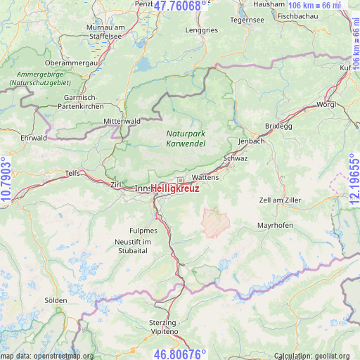
47° 17' 9.132" North, 11° 29' 36.312" East
| Map corner | latitude | longitude |
|---|---|---|
| Upper-left | 47.76068°, | 10.7903° |
| Center: | 47.28587°, | 11.49342° |
| Lower-right: | 46.80676°, | 12.19655° |
| Map W x H: | 106.1×106.1 km | = 65.9×65.9mi |
| max Lat: | 48.98333° ⇑66.4% North |
| Heiligkreuz: | 47.28587° |
| min Lat: | ⇓33.6% South 46.48841° |
| min Long | Heiligkreuz | max Long |
| 9.57802° | 11.49342° | 17.1° |
| W 8.6%⇐ | ⇒91.4% E |
Elevation
Elevation of Heiligkreuz is 572 m = 1877 ft, and this is 66.5 m = 218 ft above average elevation for this country.
| Max E: |
2140 m = 7021 ft | 31.9% |
| Heiligkreuz | 572 m 1877 ft | |
| Avg. | 505.5 m = 1658 ft | |
Min E: |
118 m = 387 ft | 68.1% |
See also: Austria elevation on elevation.city.
Geographical zone
Heiligkreuz is located in North temperate zone (between Tropic of Cancer and the Arctic Circle). Distance of this North polar circle is 2143.5 km =1331.9 mi to North.| Distance of | km | miles | from Heiligkreuz |
|---|---|---|---|
| North Pole | 4749.4 | 2951.1 | to North |
| Arctic Circle | 2143.5 | 1331.9 | to North |
| Tropic Cancer | 2651.8 | 1647.8 | to South |
| Equator | 5257.7 | 3267 | to South |


Nearby cities:
15 places around Heiligkreuz: (largest is in red/bold)
• Absam
1.4 km =0.9 mi,  40°
40°
• Aldrans
5.2 km =3.2 mi,  219°
219°
• Ampass
3.5 km =2.2 mi, 222°
• Arzl
4.5 km =2.8 mi,  266°
266°
• Baumkirchen
5.7 km =3.5 mi,  74°
74°
• Gnadenwald
6.5 km =4 mi,  58°
58°
• Hall in Tirol
1.8 km =1.1 mi,  99°
99°
• Mils bei Solbad Hall
3 km =1.9 mi, 95°
• Pradl
6.3 km =3.9 mi,  248°
248°
• Rinn
4 km =2.5 mi,  172°
172°
• Rum
3.3 km =2.1 mi, 265°
• Sistrans
6.7 km =4.2 mi,  209°
209°
• Thaur
1.7 km =1.1 mi,  305°
305°
• Tulfes
4.3 km =2.7 mi,  135°
135°
• Volders
5.5 km =3.4 mi,  92°
92°
Sources, notices
• [Note1] Compared only with cities in Austria existing in our database
• [Src1] Map data: © OpenStreetMap contributors (CC-BY-SA)
• [Src2] Other city data from geonames.org with taken over terms of usage.
• [Src3] Geographical zone / Annual Mean Temperature by Robert A. Rohde @ Wikipedia
