Altlichtenwarth geodata
Altlichtenwarth (Lower Austria) is a seat of a third-order administrative division; located in Austria in Europe/Vienna (GMT+2) time zone. With population of 769 people, there are 1680 cities with bigger population in this country. Compared to other cities in Austria, 97.2% of cities are located further ↓South; 98.2% of cities are located further ←West and 89.3% of cities have higher elevation than Altlichtenwarth. Note1
Administrative division(s):
- Level 1: Lower Austria
- Level 2: Politischer Bezirk Mistelbach
- Level 3: Altlichtenwarth


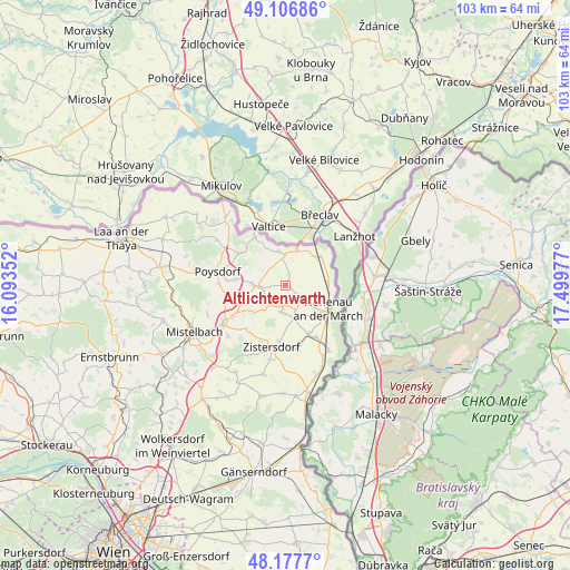
Altlichtenwarth GPS coordinates[2]
48° 38' 39.912" North, 16° 47' 47.904" East
| Map corner | latitude | longitude |
|---|---|---|
| Upper-left | 49.10686°, | 16.09352° |
| Center: | 48.64442°, | 16.79664° |
| Lower-right: | 48.1777°, | 17.49977° |
| Map W x H: | 103.3×103.3 km | = 64.2×64.2mi |
| max Lat: | 48.98333° ⇑2.8% North |
| Altlichtenwarth: | 48.64442° |
| min Lat: | ⇓97.2% South 46.48841° |
| min Long | Altlichtenwarth | max Long |
| 9.57802° | 16.79664° | 17.1° |
| W 98.2%⇐ | ⇒1.8% E |
Elevation
Elevation of Altlichtenwarth is 217 m = 712 ft, and this is 288.5 m = 947 ft below average elevation for this country.
| Max E: |
2140 m = 7021 ft | 89.3% |
| Avg. | 505.5 m = 1658 ft | |
| Altlichtenwarth | 217 m = 712 ft | |
Min E: |
118 m = 387 ft | 10.7% |
See also: Austria elevation on elevation.city.
Geographical zone
Altlichtenwarth is located in North temperate zone (between Tropic of Cancer and the Arctic Circle). Distance of this North polar circle is 1992.4 km =1238 mi to North.| Distance of | km | miles | from Altlichtenwarth |
|---|---|---|---|
| North Pole | 4598.3 | 2857.3 | to North |
| Arctic Circle | 1992.4 | 1238 | to North |
| Tropic Cancer | 2802.8 | 1741.6 | to South |
| Equator | 5408.8 | 3360.9 | to South |


Nearby cities:
15 places around Altlichtenwarth: (largest is in red/bold)
• Bernhardsthal
7.5 km =4.7 mi,  45°
45°
• Bullendorf
11.7 km =7.3 mi,  234°
234°
• Dobermannsdorf
5.2 km =3.2 mi,  163°
163°
• Großkrut
5.4 km =3.4 mi,  269°
269°
• Hausbrunn
3.1 km =1.9 mi,  131°
131°
• Hauskirchen
5.4 km =3.4 mi,  204°
204°
• Herrnbaumgarten
10.1 km =6.3 mi,  304°
304°
• Hohenau
9.1 km =5.7 mi,  119°
119°
• Neusiedl an der Zaya
5.2 km =3.2 mi,  193°
193°
• Niederabsdorf
9.5 km =5.9 mi, 155°
• Palterndorf
7 km =4.3 mi,  167°
167°
• Rabensburg
7.6 km =4.7 mi,  85°
85°
• Ringelsdorf
10.1 km =6.3 mi,  149°
149°
• Schrattenberg
10.4 km =6.5 mi,  328°
328°
• Zistersdorf
11.6 km =7.2 mi, 192°
Sources, notices
• [Note1] Compared only with cities in Austria existing in our database
• [Src1] Map data: © OpenStreetMap contributors (CC-BY-SA)
• [Src2] Other city data from geonames.org with taken over terms of usage.
• [Src3] Geographical zone / Annual Mean Temperature by Robert A. Rohde @ Wikipedia
