Althofen geodata
Althofen (Carinthia) is a seat of a third-order administrative division; located in Austria in Europe/Vienna (GMT+2) time zone. With population of 3,531 people, there are 307 cities with bigger population in this country. Compared to other cities in Austria, 88.9% of cities are located further ↑North; 53.9% of cities are located further →East and 78.1% of cities have lower elevation than Althofen. Note1
Administrative division(s):
- Level 1: Carinthia
- Level 2: Politischer Bezirk Sankt Veit an der Glan
- Level 3: Althofen


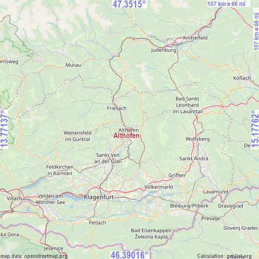
Althofen GPS coordinates[2]
46° 52' 22.728" North, 14° 28' 28.164" East
| Map corner | latitude | longitude |
|---|---|---|
| Upper-left | 47.3515°, | 13.77137° |
| Center: | 46.87298°, | 14.47449° |
| Lower-right: | 46.39016°, | 15.17762° |
| Map W x H: | 106.9×106.9 km | = 66.4×66.4mi |
| max Lat: | 48.98333° ⇑88.9% North |
| Althofen: | 46.87298° |
| min Lat: | ⇓11.1% South 46.48841° |
| min Long | Althofen | max Long |
| 9.57802° | 14.47449° | 17.1° |
| W 46.1%⇐ | ⇒53.9% E |
Elevation
Elevation of Althofen is 688 m = 2257 ft, and this is 182.5 m = 599 ft above average elevation for this country.
| Max E: |
2140 m = 7021 ft | 21.9% |
| Althofen | 688 m 2257 ft | |
| Avg. | 505.5 m = 1658 ft | |
Min E: |
118 m = 387 ft | 78.1% |
See also: Austria elevation on elevation.city.
Geographical zone
Althofen is located in North temperate zone (between Tropic of Cancer and the Arctic Circle). Distance of this North polar circle is 2189.4 km =1360.4 mi to North.| Distance of | km | miles | from Althofen |
|---|---|---|---|
| North Pole | 4795.3 | 2979.7 | to North |
| Arctic Circle | 2189.4 | 1360.4 | to North |
| Tropic Cancer | 2605.9 | 1619.2 | to South |
| Equator | 5211.8 | 3238.5 | to South |


Nearby cities:
15 places around Althofen: (largest is in red/bold)
• Eberstein
9.7 km =6 mi,  137°
137°
• Friesach
10.5 km =6.5 mi,  330°
330°
• Gurk
13.9 km =8.6 mi,  270°
270°
• Guttaring
3.1 km =1.9 mi,  63°
63°
• Hüttenberg
9.5 km =5.9 mi,  37°
37°
• Kappel am Krappfeld
3.9 km =2.4 mi,  166°
166°
• Klein Sankt Paul
6.5 km =4 mi,  128°
128°
• Kraig
10.5 km =6.5 mi,  230°
230°
• Launsdorf
11.5 km =7.1 mi,  188°
188°
• Micheldorf
6.5 km =4 mi,  317°
317°
• Micheldorf in Kärnten
5.9 km =3.7 mi, 322°
• Mölbling
4 km =2.5 mi, 230°
• St. Georgen am Längsee
10.8 km =6.7 mi,  198°
198°
• Straßburg-Stadt
11.3 km =7 mi,  282°
282°
• Treibach
0.9 km =0.6 mi,  220°
220°
Sources, notices
• [Note1] Compared only with cities in Austria existing in our database
• [Src1] Map data: © OpenStreetMap contributors (CC-BY-SA)
• [Src2] Other city data from geonames.org with taken over terms of usage.
• [Src3] Geographical zone / Annual Mean Temperature by Robert A. Rohde @ Wikipedia
