Adlwang geodata
Adlwang (Upper Austria) is a seat of a third-order administrative division; located in Austria in Europe/Vienna (GMT+2) time zone. With population of 1,806 people, there are 690 cities with bigger population in this country. Compared to other cities in Austria, 65.6% of cities are located further ↓South; 60.1% of cities are located further →East and 55.9% of cities have higher elevation than Adlwang. Note1
Administrative division(s):
- Level 1: Upper Austria
- Level 2: Politischer Bezirk Steyr-Land
- Level 3: Adlwang


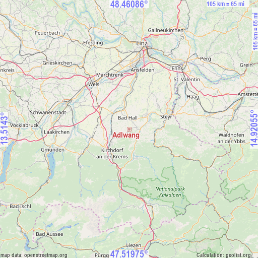
Adlwang GPS coordinates[2]
47° 59' 32.82" North, 14° 13' 2.712" East
| Map corner | latitude | longitude |
|---|---|---|
| Upper-left | 48.46086°, | 13.5143° |
| Center: | 47.99245°, | 14.21742° |
| Lower-right: | 47.51975°, | 14.92055° |
| Map W x H: | 104.6×104.6 km | = 65×65mi |
| max Lat: | 48.98333° ⇑34.4% North |
| Adlwang: | 47.99245° |
| min Lat: | ⇓65.6% South 46.48841° |
| min Long | Adlwang | max Long |
| 9.57802° | 14.21742° | 17.1° |
| W 39.9%⇐ | ⇒60.1% E |
Elevation
Elevation of Adlwang is 413 m = 1355 ft, and this is 92.5 m = 303 ft below average elevation for this country.
| Max E: |
2140 m = 7021 ft | 55.9% |
| Avg. | 505.5 m = 1658 ft | |
| Adlwang | 413 m = 1355 ft | |
Min E: |
118 m = 387 ft | 44.1% |
See also: Austria elevation on elevation.city.
Geographical zone
Adlwang is located in North temperate zone (between Tropic of Cancer and the Arctic Circle). Distance of this North polar circle is 2064.9 km =1283.1 mi to North.| Distance of | km | miles | from Adlwang |
|---|---|---|---|
| North Pole | 4670.8 | 2902.3 | to North |
| Arctic Circle | 2064.9 | 1283.1 | to North |
| Tropic Cancer | 2730.3 | 1696.5 | to South |
| Equator | 5336.3 | 3315.8 | to South |


Nearby cities:
15 places around Adlwang: (largest is in red/bold)
• Aschach an der Steyr
9.1 km =5.7 mi,  75°
75°
• Bad Hall
5.2 km =3.2 mi,  351°
351°
• Feyregg
4.7 km =2.9 mi,  333°
333°
• Grünburg
4.2 km =2.6 mi,  122°
122°
• Nussbach
4.6 km =2.9 mi,  240°
240°
• Obergrünburg
5.4 km =3.4 mi,  148°
148°
• Pfarrkirchen bei Bad Hall
4.4 km =2.7 mi,  342°
342°
• Rohr im Kremstal
8.7 km =5.4 mi, 347°
• Sierning
8.9 km =5.5 mi,  50°
50°
• Steinbach an der Steyr
4.6 km =2.9 mi, 121°
• Strienzing
8.6 km =5.3 mi,  260°
260°
• Untergrünburg
4.2 km =2.6 mi, 123°
• Waldneukirchen
3.2 km =2 mi, 77°
• Wartberg an der Krems
7.4 km =4.6 mi,  267°
267°
• Zehetner
5.7 km =3.5 mi,  130°
130°
Sources, notices
• [Note1] Compared only with cities in Austria existing in our database
• [Src1] Map data: © OpenStreetMap contributors (CC-BY-SA)
• [Src2] Other city data from geonames.org with taken over terms of usage.
• [Src3] Geographical zone / Annual Mean Temperature by Robert A. Rohde @ Wikipedia
