Sierning geodata
Sierning (Upper Austria) is a populated place; located in Austria in Europe/Vienna (GMT+2) time zone. With population of 4,025 people, there are 259 cities with bigger population in this country. Compared to other cities in Austria, 69% of cities are located further ↓South; 57.5% of cities are located further →East and 63.9% of cities have higher elevation than Sierning. Note1
Administrative division(s):
- Level 1: Upper Austria
- Level 2: Politischer Bezirk Steyr-Land
- Level 3: Sierning


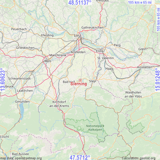
Sierning GPS coordinates[2]
48° 2' 36.348" North, 14° 18' 33.66" East
| Map corner | latitude | longitude |
|---|---|---|
| Upper-left | 48.51137°, | 13.60623° |
| Center: | 48.04343°, | 14.30935° |
| Lower-right: | 47.5712°, | 15.01248° |
| Map W x H: | 104.5×104.5 km | = 64.9×64.9mi |
| max Lat: | 48.98333° ⇑31% North |
| Sierning: | 48.04343° |
| min Lat: | ⇓69% South 46.48841° |
| min Long | Sierning | max Long |
| 9.57802° | 14.30935° | 17.1° |
| W 42.5%⇐ | ⇒57.5% E |
Elevation
Elevation of Sierning is 359 m = 1178 ft, and this is 146.5 m = 481 ft below average elevation for this country.
| Max E: |
2140 m = 7021 ft | 63.9% |
| Avg. | 505.5 m = 1658 ft | |
| Sierning | 359 m = 1178 ft | |
Min E: |
118 m = 387 ft | 36.1% |
See also: Austria elevation on elevation.city.
Geographical zone
Sierning is located in North temperate zone (between Tropic of Cancer and the Arctic Circle). Distance of this North polar circle is 2059.2 km =1279.5 mi to North.| Distance of | km | miles | from Sierning |
|---|---|---|---|
| North Pole | 4665.1 | 2898.8 | to North |
| Arctic Circle | 2059.2 | 1279.5 | to North |
| Tropic Cancer | 2736 | 1700.1 | to South |
| Equator | 5341.9 | 3319.3 | to South |


Nearby cities:
15 places around Sierning: (largest is in red/bold)
• Adlwang
8.9 km =5.5 mi,  230°
230°
• Aschach an der Steyr
3.9 km =2.4 mi,  150°
150°
• Bad Hall
7.6 km =4.7 mi,  265°
265°
• Garsten
7.7 km =4.8 mi,  107°
107°
• Grünburg
8.6 km =5.3 mi,  202°
202°
• Lahrndorf
7.5 km =4.7 mi,  135°
135°
• Losensteinleithen
8.8 km =5.5 mi,  23°
23°
• Neuzeug
1.9 km =1.2 mi,  67°
67°
• Pfarrkirchen bei Bad Hall
8.3 km =5.2 mi,  260°
260°
• Steinbach an der Steyr
8.6 km =5.3 mi, 200°
• Steyr
8.3 km =5.2 mi,  90°
90°
• Untergrünburg
8.6 km =5.3 mi, 202°
• Waldneukirchen
6.2 km =3.9 mi,  216°
216°
• Weichstetten
8.7 km =5.4 mi,  5°
5°
• Wolfern
6.4 km =4 mi,  46°
46°
Sources, notices
• [Note1] Compared only with cities in Austria existing in our database
• [Src1] Map data: © OpenStreetMap contributors (CC-BY-SA)
• [Src2] Other city data from geonames.org with taken over terms of usage.
• [Src3] Geographical zone / Annual Mean Temperature by Robert A. Rohde @ Wikipedia
