Lacken geodata
Lacken (Upper Austria) is a populated place; located in Austria in Europe/Vienna (GMT+2) time zone. With population of 662 people, there are 1951 cities with bigger population in this country. Compared to other cities in Austria, 89.8% of cities are located further ↓South; 63.1% of cities are located further →East and 53% of cities have higher elevation than Lacken. Note1
Administrative division(s):
- Level 1: Upper Austria
- Level 2: Politischer Bezirk Urfahr-Umgebung
- Level 3: Feldkirchen an der Donau


Lacken GPS coordinates[2]
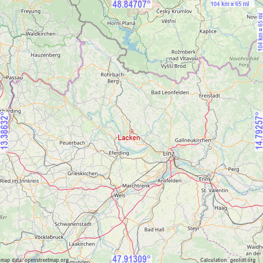
48° 22' 55.992" North, 14° 5' 21.984" East
| Map corner | latitude | longitude |
|---|---|---|
| Upper-left | 48.84707°, | 13.38632° |
| Center: | 48.38222°, | 14.08944° |
| Lower-right: | 47.91309°, | 14.79257° |
| Map W x H: | 103.8×103.8 km | = 64.5×64.5mi |
| max Lat: | 48.98333° ⇑10.2% North |
| Lacken: | 48.38222° |
| min Lat: | ⇓89.8% South 46.48841° |
| min Long | Lacken | max Long |
| 9.57802° | 14.08944° | 17.1° |
| W 36.9%⇐ | ⇒63.1% E |
Elevation
Elevation of Lacken is 435 m = 1427 ft, and this is 70.5 m = 231 ft below average elevation for this country.
| Max E: |
2140 m = 7021 ft | 53% |
| Avg. | 505.5 m = 1658 ft | |
| Lacken | 435 m = 1427 ft | |
Min E: |
118 m = 387 ft | 47% |
See also: Austria elevation on elevation.city.
Geographical zone
Lacken is located in North temperate zone (between Tropic of Cancer and the Arctic Circle). Distance of this North polar circle is 2021.6 km =1256.2 mi to North.| Distance of | km | miles | from Lacken |
|---|---|---|---|
| North Pole | 4627.5 | 2875.4 | to North |
| Arctic Circle | 2021.6 | 1256.2 | to North |
| Tropic Cancer | 2773.7 | 1723.5 | to South |
| Equator | 5379.6 | 3342.7 | to South |


Nearby cities:
15 places around Lacken: (largest is in red/bold)
• Aschach an der Donau
5.5 km =3.4 mi,  248°
248°
• Bergheim
3.8 km =2.4 mi,  228°
228°
• Feldkirchen an der Donau
5 km =3.1 mi,  214°
214°
• Freudenstein
3.4 km =2.1 mi,  173°
173°
• Goldwörth
6.2 km =3.9 mi, 172°
• Gramastetten
7.6 km =4.7 mi,  91°
91°
• Hartkirchen
6.6 km =4.1 mi, 251°
• Herzogsdorf
5.6 km =3.5 mi,  17°
17°
• Niederottensheim
8.6 km =5.3 mi,  123°
123°
• Niederwaldkirchen
7.6 km =4.7 mi,  357°
357°
• Ottensheim
8.4 km =5.2 mi,  131°
131°
• Sankt Gotthard im Mühlkreis
3.1 km =1.9 mi, 94°
• Sankt Martin im Mühlkreis
5.3 km =3.3 mi,  314°
314°
• Türkstetten
9.1 km =5.7 mi,  98°
98°
• Walding
6 km =3.7 mi, 123°
Sources, notices
• [Note1] Compared only with cities in Austria existing in our database
• [Src1] Map data: © OpenStreetMap contributors (CC-BY-SA)
• [Src2] Other city data from geonames.org with taken over terms of usage.
• [Src3] Geographical zone / Annual Mean Temperature by Robert A. Rohde @ Wikipedia
