Haid geodata
Haid (Upper Austria) is a populated place; located in Austria in Europe/Vienna (GMT+2) time zone. With population of 507 people, there are 2487 cities with bigger population in this country. Compared to other cities in Austria, 87% of cities are located further ↓South; 55% of cities are located further →East and 59% of cities have higher elevation than Haid. Note1
Administrative division(s):
- Level 1: Upper Austria
- Level 2: Politischer Bezirk Urfahr-Umgebung
- Level 3: Engerwitzdorf


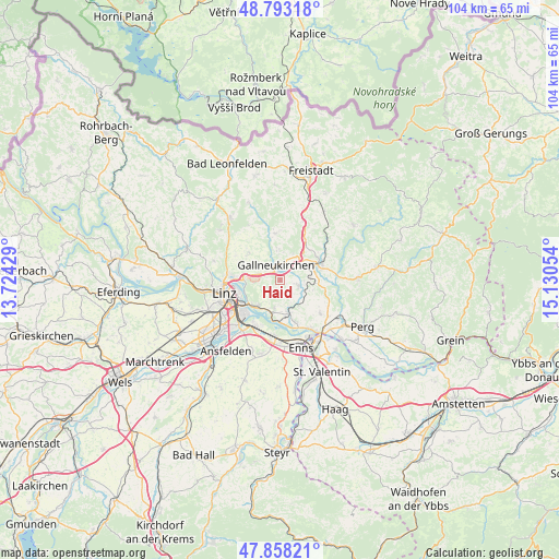
Haid GPS coordinates[2]
48° 19' 40.224" North, 14° 25' 38.676" East
| Map corner | latitude | longitude |
|---|---|---|
| Upper-left | 48.79318°, | 13.72429° |
| Center: | 48.32784°, | 14.42741° |
| Lower-right: | 47.85821°, | 15.13054° |
| Map W x H: | 104×104 km | = 64.6×64.6mi |
| max Lat: | 48.98333° ⇑13% North |
| Haid: | 48.32784° |
| min Lat: | ⇓87% South 46.48841° |
| min Long | Haid | max Long |
| 9.57802° | 14.42741° | 17.1° |
| W 45%⇐ | ⇒55% E |
Elevation
Elevation of Haid is 392 m = 1286 ft, and this is 113.5 m = 372 ft below average elevation for this country.
| Max E: |
2140 m = 7021 ft | 59% |
| Avg. | 505.5 m = 1658 ft | |
| Haid | 392 m = 1286 ft | |
Min E: |
118 m = 387 ft | 41% |
See also: Austria elevation on elevation.city.
Geographical zone
Haid is located in North temperate zone (between Tropic of Cancer and the Arctic Circle). Distance of this North polar circle is 2027.6 km =1259.9 mi to North.| Distance of | km | miles | from Haid |
|---|---|---|---|
| North Pole | 4633.5 | 2879.1 | to North |
| Arctic Circle | 2027.6 | 1259.9 | to North |
| Tropic Cancer | 2767.6 | 1719.7 | to South |
| Equator | 5373.6 | 3339 | to South |


Nearby cities:
15 places around Haid: (largest is in red/bold)
• Aussertreffling
5.8 km =3.6 mi,  276°
276°
• Engerwitzdorf
2.2 km =1.4 mi,  29°
29°
• Gallneukirchen
3 km =1.9 mi,  343°
343°
• Innertreffling
4.3 km =2.7 mi,  297°
297°
• Katsdorf
3.6 km =2.2 mi,  107°
107°
• Linzerberg
2.3 km =1.4 mi,  321°
321°
• Luftenberg an der Donau
6 km =3.7 mi,  190°
190°
• Mittertreffling
4.8 km =3 mi, 284°
• Plesching
6.7 km =4.2 mi,  263°
263°
• Sankt Georgen an der Gusen
6.4 km =4 mi,  165°
165°
• Schweinbach
1.4 km =0.9 mi,  345°
345°
• Statzing
5.9 km =3.7 mi,  178°
178°
• Steyregg
6.4 km =4 mi,  221°
221°
• Unterweitersdorf
5.3 km =3.3 mi, 34°
• Wartberg ob der Aist
6.4 km =4 mi,  69°
69°
Sources, notices
• [Note1] Compared only with cities in Austria existing in our database
• [Src1] Map data: © OpenStreetMap contributors (CC-BY-SA)
• [Src2] Other city data from geonames.org with taken over terms of usage.
• [Src3] Geographical zone / Annual Mean Temperature by Robert A. Rohde @ Wikipedia
