Wartberg ob der Aist geodata
Wartberg ob der Aist (Upper Austria) is a seat of a third-order administrative division; located in Austria in Europe/Vienna (GMT+2) time zone. With population of 1,206 people, there are 1040 cities with bigger population in this country. Compared to other cities in Austria, 88.3% of cities are located further ↓South; 53% of cities are located further →East and 51.8% of cities have lower elevation than Wartberg ob der Aist. Note1
Administrative division(s):
- Level 1: Upper Austria
- Level 2: Politischer Bezirk Freistadt
- Level 3: Wartberg ob der Aist


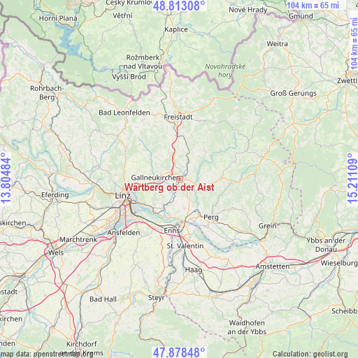
Wartberg ob der Aist GPS coordinates[2]
48° 20' 52.512" North, 14° 30' 28.656" East
| Map corner | latitude | longitude |
|---|---|---|
| Upper-left | 48.81308°, | 13.80484° |
| Center: | 48.34792°, | 14.50796° |
| Lower-right: | 47.87848°, | 15.21109° |
| Map W x H: | 103.9×103.9 km | = 64.6×64.6mi |
| max Lat: | 48.98333° ⇑11.7% North |
| Wartberg ob der Aist: | 48.34792° |
| min Lat: | ⇓88.3% South 46.48841° |
| min Long | Wartberg ob der | max Long |
| 9.57802° | 14.50796° | 17.1° |
| W 47%⇐ | ⇒53% E |
Elevation
Elevation of Wartberg ob der Aist is 462 m = 1516 ft, and this is 43.5 m = 143 ft below average elevation for this country.
| Max E: |
2140 m = 7021 ft | 48.2% |
| Avg. | 505.5 m = 1658 ft | |
| Wartberg ob der Aist | 462 m = 1516 ft | |
Min E: |
118 m = 387 ft | 51.8% |
See also: Austria elevation on elevation.city.
Geographical zone
Wartberg ob der Aist is located in North temperate zone (between Tropic of Cancer and the Arctic Circle). Distance of this North polar circle is 2025.4 km =1258.5 mi to North.| Distance of | km | miles | from Wartberg ob der Aist |
|---|---|---|---|
| North Pole | 4631.3 | 2877.8 | to North |
| Arctic Circle | 2025.4 | 1258.5 | to North |
| Tropic Cancer | 2769.9 | 1721.1 | to South |
| Equator | 5375.8 | 3340.4 | to South |


Nearby cities:
15 places around Wartberg ob der Aist: (largest is in red/bold)
• Blindendorf
8.3 km =5.2 mi,  189°
189°
• Doppl
8.5 km =5.3 mi,  148°
148°
• Engerwitzdorf
4.9 km =3 mi,  266°
266°
• Gallneukirchen
6.8 km =4.2 mi,  275°
275°
• Grünbichl
1.1 km =0.7 mi,  84°
84°
• Hagenberg im Mühlkreis
2.3 km =1.4 mi,  16°
16°
• Haid
6.4 km =4 mi,  249°
249°
• Katsdorf
4.2 km =2.6 mi,  216°
216°
• Linzerberg
7.4 km =4.6 mi, 266°
• Pregarten
1.9 km =1.2 mi,  66°
66°
• Ried in der Riedmark
8.7 km =5.4 mi,  170°
170°
• Schweinbach
6.4 km =4 mi,  262°
262°
• Tragwein
8.6 km =5.3 mi,  100°
100°
• Unterjosefstal
7.9 km =4.9 mi,  141°
141°
• Unterweitersdorf
3.7 km =2.3 mi,  306°
306°
Sources, notices
• [Note1] Compared only with cities in Austria existing in our database
• [Src1] Map data: © OpenStreetMap contributors (CC-BY-SA)
• [Src2] Other city data from geonames.org with taken over terms of usage.
• [Src3] Geographical zone / Annual Mean Temperature by Robert A. Rohde @ Wikipedia
