Riedersbach geodata
Riedersbach (Upper Austria) is a populated place; located in Austria in Europe/Vienna (GMT+2) time zone. With population of 810 people, there are 1593 cities with bigger population in this country. Compared to other cities in Austria, 68% of cities are located further ↓South; 84.1% of cities are located further →East and 58.2% of cities have higher elevation than Riedersbach. Note1
Administrative division(s):
- Level 1: Upper Austria
- Level 2: Politischer Bezirk Braunau am Inn
- Level 3: Sankt Pantaleon


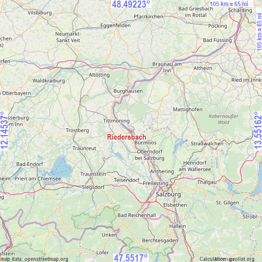
Riedersbach GPS coordinates[2]
48° 1' 26.796" North, 12° 50' 54.564" East
| Map corner | latitude | longitude |
|---|---|---|
| Upper-left | 48.49223°, | 12.14537° |
| Center: | 48.02411°, | 12.84849° |
| Lower-right: | 47.5517°, | 13.55162° |
| Map W x H: | 104.6×104.6 km | = 65×65mi |
| max Lat: | 48.98333° ⇑32% North |
| Riedersbach: | 48.02411° |
| min Lat: | ⇓68% South 46.48841° |
| min Long | Riedersbach | max Long |
| 9.57802° | 12.84849° | 17.1° |
| W 15.9%⇐ | ⇒84.1% E |
Elevation
Elevation of Riedersbach is 396 m = 1299 ft, and this is 109.5 m = 359 ft below average elevation for this country.
| Max E: |
2140 m = 7021 ft | 58.2% |
| Avg. | 505.5 m = 1658 ft | |
| Riedersbach | 396 m = 1299 ft | |
Min E: |
118 m = 387 ft | 41.8% |
See also: Austria elevation on elevation.city.
Geographical zone
Riedersbach is located in North temperate zone (between Tropic of Cancer and the Arctic Circle). Distance of this North polar circle is 2061.4 km =1280.9 mi to North.| Distance of | km | miles | from Riedersbach |
|---|---|---|---|
| North Pole | 4667.3 | 2900.1 | to North |
| Arctic Circle | 2061.4 | 1280.9 | to North |
| Tropic Cancer | 2733.9 | 1698.8 | to South |
| Equator | 5339.8 | 3318 | to South |


Nearby cities:
15 places around Riedersbach: (largest is in red/bold)
• Berndorf bei Salzburg
16.2 km =10.1 mi,  101°
101°
• Bürmoos
6.9 km =4.3 mi,  131°
131°
• Dorfbeuern
12.5 km =7.8 mi,  93°
93°
• Duttendorf
14 km =8.7 mi,  0°
0°
• Eching
6.4 km =4 mi,  152°
152°
• Eggelsberg
12.2 km =7.6 mi,  59°
59°
• Hochburg-Ach
12 km =7.5 mi,  10°
10°
• Lamprechtshausen
8.7 km =5.4 mi,  114°
114°
• Moosdorf
10.7 km =6.6 mi,  77°
77°
• Nußdorf am Haunsberg
14 km =8.7 mi,  121°
121°
• Oberndorf bei Salzburg
10.4 km =6.5 mi,  142°
142°
• Ostermiething
2.9 km =1.8 mi,  330°
330°
• Sankt Georgen am Fillmannsbach
16.4 km =10.2 mi,  46°
46°
• Sankt Pantaleon
3.9 km =2.4 mi, 118°
• Wagnergraben
13.1 km =8.1 mi, 91°
Sources, notices
• [Note1] Compared only with cities in Austria existing in our database
• [Src1] Map data: © OpenStreetMap contributors (CC-BY-SA)
• [Src2] Other city data from geonames.org with taken over terms of usage.
• [Src3] Geographical zone / Annual Mean Temperature by Robert A. Rohde @ Wikipedia
