Whyalla geodata
Whyalla (South Australia) is a seat of a second-order administrative division; located in Australia in Australia/Adelaide (GMT+10.5) time zone. With population of 3,623 people, there are 1945 cities with bigger population in this country. Compared to other cities in Australia, 57.1% of cities are located further ↓South; 85.8% of cities are located further →East and 73.6% of cities have higher elevation than Whyalla. Note1


Whyalla GPS coordinates[2]
33° 1' 57.648" South, 137° 33' 53.388" East
| Map corner | latitude | longitude |
|---|---|---|
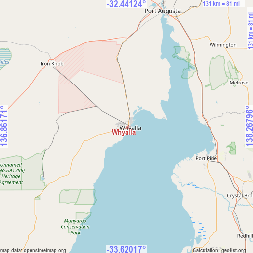
| Upper-left | -32.44124°, | 136.86171° |
| Center: | -33.03268°, | 137.56483° |
| Lower-right: | -33.62017°, | 138.26796° |
| Map W x H: | 131.1×131.1 km | = 81.5×81.5mi |
| max Lat: | -10.58257° ⇑42.9% North |
| Whyalla: | -33.03268° |
| min Lat: | ⇓57.1% South -43.31423° |
| min Long | Whyalla | max Long |
| 113.53327° | 137.56483° | 153.61246° |
| W 14.2%⇐ | ⇒85.8% E |
Elevation
Elevation of Whyalla is 20 m = 66 ft, and this is 102 m = 335 ft below average elevation for this country.
| Max E: |
1715 m = 5627 ft | 73.6% |
| Avg. | 122 m = 400 ft | |
| Whyalla | 20 m = 66 ft | |
Min E: |
-2 m = -7 ft | 26.4% |
See also: Australia elevation on elevation.city.
Geographical zone
Whyalla is located in South temperate zone (between Tropic of Capricorn and the Antarctic Circle). Distance of this Southern Tropic circle is 1067 km =663 mi to North.| Distance of | km | miles | from Whyalla |
|---|---|---|---|
| Equator | 3672.9 | 2282.2 | to North |
| Tropic Capricorn | 1067 | 663 | to North |
| Antarctic Circle | 3728.3 | 2316.7 | to South |
| South Pole | 6334.2 | 3935.9 | to South |


Nearby cities:
15 places around Whyalla: (largest is in red/bold)
• Napperby
53.2 km =33.1 mi,  105°
105°
• Port Augusta
62.8 km =39 mi,  18°
18°
• Port Augusta West
63.4 km =39.4 mi, 16°
• Port Pirie
45.7 km =28.4 mi, 112°
• Port Pirie South
45.7 km =28.4 mi, 113°
• Port Pirie West
43.5 km =27 mi, 111°
• Risdon Park
43.9 km =27.3 mi, 114°
• Risdon Park South
44.7 km =27.8 mi,  116°
116°
• Solomontown
46 km =28.6 mi, 111°
• Stirling North
66.6 km =41.4 mi, 22°
• Whyalla Jenkins
5 km =3.1 mi,  283°
283°
• Whyalla Norrie
2.4 km =1.5 mi, 279°
• Whyalla Playford
0.6 km =0.4 mi,  333°
333°
• Whyalla Stuart
3.8 km =2.4 mi, 282°
• Wilmington
65.5 km =40.7 mi,  49°
49°
Sources, notices
• [Note1] Compared only with cities in Australia existing in our database
• [Src1] Map data: © OpenStreetMap contributors (CC-BY-SA)
• [Src2] Other city data from geonames.org with taken over terms of usage.
• [Src3] Geographical zone / Annual Mean Temperature by Robert A. Rohde @ Wikipedia
