Wilmington geodata
Wilmington (South Australia) is a populated place; located in Australia in Australia/Adelaide (GMT+10.5) time zone. With population of 560 people, there are 4680 cities with bigger population in this country. Compared to other cities in Australia, 60.9% of cities are located further ↓South; 85.3% of cities are located further →East and 88.6% of cities have lower elevation than Wilmington. Note1


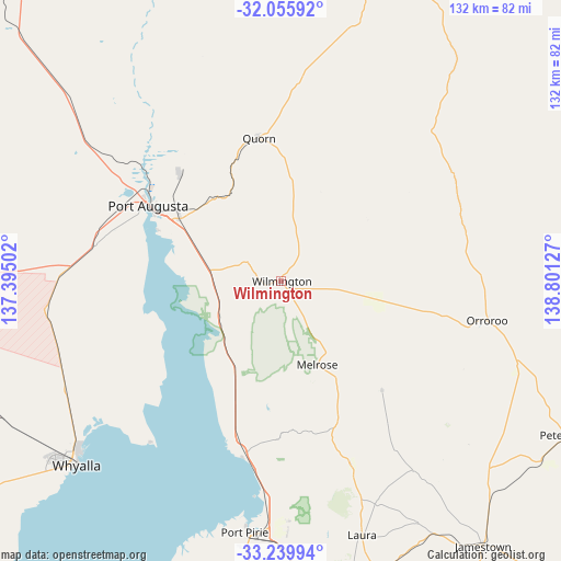
Wilmington GPS coordinates[2]
32° 38' 59.604" South, 138° 5' 53.304" East
| Map corner | latitude | longitude |
|---|---|---|
| Upper-left | -32.05592°, | 137.39502° |
| Center: | -32.64989°, | 138.09814° |
| Lower-right: | -33.23994°, | 138.80127° |
| Map W x H: | 131.7×131.7 km | = 81.8×81.8mi |
| max Lat: | -10.58257° ⇑39.1% North |
| Wilmington: | -32.64989° |
| min Lat: | ⇓60.9% South -43.31423° |
| min Long | Wilmington | max Long |
| 113.53327° | 138.09814° | 153.61246° |
| W 14.7%⇐ | ⇒85.3% E |
Elevation
Elevation of Wilmington is 329 m = 1079 ft, and this is 207 m = 679 ft above average elevation for this country.
| Max E: |
1715 m = 5627 ft | 11.4% |
| Wilmington | 329 m 1079 ft | |
| Avg. | 122 m = 400 ft | |
Min E: |
-2 m = -7 ft | 88.6% |
See also: Australia elevation on elevation.city.
Geographical zone
Wilmington is located in South temperate zone (between Tropic of Capricorn and the Antarctic Circle). Distance of this Southern Tropic circle is 1024.4 km =636.5 mi to North.| Distance of | km | miles | from Wilmington |
|---|---|---|---|
| Equator | 3630.3 | 2255.8 | to North |
| Tropic Capricorn | 1024.4 | 636.5 | to North |
| Antarctic Circle | 3770.8 | 2343.1 | to South |
| South Pole | 6376.7 | 3962.3 | to South |


Nearby cities:
15 places around Wilmington: (largest is in red/bold)
• Laura
62.5 km =38.8 mi,  162°
162°
• Napperby
56.5 km =35.1 mi,  178°
178°
• Orroroo
49.2 km =30.6 mi,  101°
101°
• Port Augusta
35 km =21.7 mi,  299°
299°
• Port Augusta West
36.7 km =22.8 mi, 299°
• Port Pirie
60.7 km =37.7 mi,  187°
187°
• Port Pirie South
61.4 km =38.2 mi, 187°
• Port Pirie West
59.4 km =36.9 mi, 189°
• Quorn
34.1 km =21.2 mi,  351°
351°
• Risdon Park
61.6 km =38.3 mi, 189°
• Risdon Park South
63.1 km =39.2 mi, 188°
• Solomontown
59.9 km =37.2 mi, 186°
• Stirling North
30.8 km =19.1 mi,  307°
307°
• Whyalla
65.5 km =40.7 mi,  229°
229°
• Whyalla Playford
65.4 km =40.6 mi, 230°
Sources, notices
• [Note1] Compared only with cities in Australia existing in our database
• [Src1] Map data: © OpenStreetMap contributors (CC-BY-SA)
• [Src2] Other city data from geonames.org with taken over terms of usage.
• [Src3] Geographical zone / Annual Mean Temperature by Robert A. Rohde @ Wikipedia
