Napperby geodata
Napperby (South Australia) is a populated place; located in Australia in Australia/Adelaide (GMT+10.5) time zone. With population of 646 people, there are 4453 cities with bigger population in this country. Compared to other cities in Australia, 56.4% of cities are located further ↓South; 85.3% of cities are located further →East and 68.7% of cities have lower elevation than Napperby. Note1


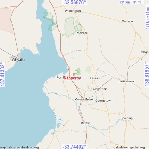
Napperby GPS coordinates[2]
33° 9' 26.532" South, 138° 6' 59.184" East
| Map corner | latitude | longitude |
|---|---|---|
| Upper-left | -32.56676°, | 137.41332° |
| Center: | -33.15737°, | 138.11644° |
| Lower-right: | -33.74402°, | 138.81957° |
| Map W x H: | 130.9×130.9 km | = 81.3×81.3mi |
| max Lat: | -10.58257° ⇑43.6% North |
| Napperby: | -33.15737° |
| min Lat: | ⇓56.4% South -43.31423° |
| min Long | Napperby | max Long |
| 113.53327° | 138.11644° | 153.61246° |
| W 14.7%⇐ | ⇒85.3% E |
Elevation
Elevation of Napperby is 95 m = 312 ft, and this is 27 m = 89 ft below average elevation for this country.
| Max E: |
1715 m = 5627 ft | 31.3% |
| Avg. | 122 m = 400 ft | |
| Napperby | 95 m = 312 ft | |
Min E: |
-2 m = -7 ft | 68.7% |
See also: Australia elevation on elevation.city.
Geographical zone
Napperby is located in South temperate zone (between Tropic of Capricorn and the Antarctic Circle). Distance of this Southern Tropic circle is 1080.8 km =671.6 mi to North.| Distance of | km | miles | from Napperby |
|---|---|---|---|
| Equator | 3686.8 | 2290.9 | to North |
| Tropic Capricorn | 1080.8 | 671.6 | to North |
| Antarctic Circle | 3714.4 | 2308 | to South |
| South Pole | 6320.3 | 3927.3 | to South |


Nearby cities:
15 places around Napperby: (largest is in red/bold)
• Crystal Brook
23.4 km =14.5 mi,  158°
158°
• Gladstone
25.4 km =15.8 mi,  118°
118°
• Jamestown
45.8 km =28.5 mi,  96°
96°
• Laura
17.6 km =10.9 mi, 100°
• Port Broughton
52.1 km =32.4 mi,  198°
198°
• Port Pirie
10 km =6.2 mi,  247°
247°
• Port Pirie South
10.5 km =6.5 mi,  244°
244°
• Port Pirie West
11.2 km =7 mi,  258°
258°
• Risdon Park
12.2 km =7.6 mi, 249°
• Risdon Park South
12.8 km =8 mi, 242°
• Solomontown
9.2 km =5.7 mi, 250°
• Whyalla
53.2 km =33.1 mi,  285°
285°
• Whyalla Norrie
55.6 km =34.5 mi,  284°
284°
• Whyalla Playford
53.6 km =33.3 mi, 285°
• Wilmington
56.5 km =35.1 mi,  358°
358°
Sources, notices
• [Note1] Compared only with cities in Australia existing in our database
• [Src1] Map data: © OpenStreetMap contributors (CC-BY-SA)
• [Src2] Other city data from geonames.org with taken over terms of usage.
• [Src3] Geographical zone / Annual Mean Temperature by Robert A. Rohde @ Wikipedia
