Waroona geodata
Waroona (Western Australia) is a populated place; located in Australia in Australia/Perth (GMT+8) time zone. With population of 2,858 people, there are 2341 cities with bigger population in this country. Compared to other cities in Australia, 59.4% of cities are located further ↓South; 93.5% of cities are located further →East and 53.1% of cities have higher elevation than Waroona. Note1


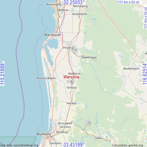
Waroona GPS coordinates[2]
32° 50' 35.628" South, 115° 55' 19.236" East
| Map corner | latitude | longitude |
|---|---|---|
| Upper-left | -32.25053°, | 115.21889° |
| Center: | -32.84323°, | 115.92201° |
| Lower-right: | -33.43199°, | 116.62514° |
| Map W x H: | 131.4×131.4 km | = 81.6×81.6mi |
| max Lat: | -10.58257° ⇑40.6% North |
| Waroona: | -32.84323° |
| min Lat: | ⇓59.4% South -43.31423° |
| min Long | Waroona | max Long |
| 113.53327° | 115.92201° | 153.61246° |
| W 6.5%⇐ | ⇒93.5% E |
Elevation
Elevation of Waroona is 41 m = 135 ft, and this is 81 m = 266 ft below average elevation for this country.
| Max E: |
1715 m = 5627 ft | 53.1% |
| Avg. | 122 m = 400 ft | |
| Waroona | 41 m = 135 ft | |
Min E: |
-2 m = -7 ft | 46.9% |
See also: Australia elevation on elevation.city.
Geographical zone
Waroona is located in South temperate zone (between Tropic of Capricorn and the Antarctic Circle). Distance of this Southern Tropic circle is 1045.9 km =649.9 mi to North.| Distance of | km | miles | from Waroona |
|---|---|---|---|
| Equator | 3651.8 | 2269.1 | to North |
| Tropic Capricorn | 1045.9 | 649.9 | to North |
| Antarctic Circle | 3749.3 | 2329.7 | to South |
| South Pole | 6355.2 | 3948.9 | to South |


Nearby cities:
15 places around Waroona: (largest is in red/bold)
• Barragup
35.2 km =21.9 mi,  337°
337°
• Bouvard
29.9 km =18.6 mi,  297°
297°
• Coodanup
36 km =22.4 mi,  334°
334°
• Cookernup
16.7 km =10.4 mi,  193°
193°
• Dawesville
36.1 km =22.4 mi,  310°
310°
• Dudley Park
37 km =23 mi, 331°
• Dwellingup
19.4 km =12.1 mi,  42°
42°
• Furnissdale
35.1 km =21.8 mi, 334°
• Harvey
26.2 km =16.3 mi,  181°
181°
• Lake Clifton
22.3 km =13.9 mi,  278°
278°
• North Dandalup
36.6 km =22.7 mi,  7°
7°
• North Yunderup
31.8 km =19.8 mi, 337°
• Pinjarra
24.2 km =15 mi,  349°
349°
• Ravenswood
30.2 km =18.8 mi, 343°
• South Yunderup
31.6 km =19.6 mi, 335°
Sources, notices
• [Note1] Compared only with cities in Australia existing in our database
• [Src1] Map data: © OpenStreetMap contributors (CC-BY-SA)
• [Src2] Other city data from geonames.org with taken over terms of usage.
• [Src3] Geographical zone / Annual Mean Temperature by Robert A. Rohde @ Wikipedia
