Harvey geodata
Harvey (Western Australia) is a populated place; located in Australia in Australia/Perth (GMT+8) time zone. With population of 3,281 people, there are 2080 cities with bigger population in this country. Compared to other cities in Australia, 56.9% of cities are located further ↓South; 93.7% of cities are located further →East and 52.8% of cities have lower elevation than Harvey. Note1


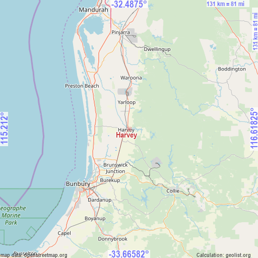
Harvey GPS coordinates[2]
33° 4' 43.068" South, 115° 54' 54.432" East
| Map corner | latitude | longitude |
|---|---|---|
| Upper-left | -32.4875°, | 115.212° |
| Center: | -33.07863°, | 115.91512° |
| Lower-right: | -33.66582°, | 116.61825° |
| Map W x H: | 131×131 km | = 81.4×81.4mi |
| max Lat: | -10.58257° ⇑43.1% North |
| Harvey: | -33.07863° |
| min Lat: | ⇓56.9% South -43.31423° |
| min Long | Harvey | max Long |
| 113.53327° | 115.91512° | 153.61246° |
| W 6.3%⇐ | ⇒93.7% E |
Elevation
Elevation of Harvey is 49 m = 161 ft, and this is 73 m = 240 ft below average elevation for this country.
| Max E: |
1715 m = 5627 ft | 47.2% |
| Avg. | 122 m = 400 ft | |
| Harvey | 49 m = 161 ft | |
Min E: |
-2 m = -7 ft | 52.8% |
See also: Australia elevation on elevation.city.
Geographical zone
Harvey is located in South temperate zone (between Tropic of Capricorn and the Antarctic Circle). Distance of this Southern Tropic circle is 1072.1 km =666.2 mi to North.| Distance of | km | miles | from Harvey |
|---|---|---|---|
| Equator | 3678 | 2285.4 | to North |
| Tropic Capricorn | 1072.1 | 666.2 | to North |
| Antarctic Circle | 3723.2 | 2313.5 | to South |
| South Pole | 6329.1 | 3932.7 | to South |


Nearby cities:
15 places around Harvey: (largest is in red/bold)
• Allanson
33.3 km =20.7 mi,  149°
149°
• Australind
29.1 km =18.1 mi,  219°
219°
• Binningup
21.9 km =13.6 mi,  249°
249°
• Brunswick
17.8 km =11.1 mi,  195°
195°
• Burekup
27.1 km =16.8 mi, 200°
• Cookernup
10.4 km =6.5 mi,  341°
341°
• East Bunbury
37.2 km =23.1 mi, 219°
• Eaton
32.9 km =20.4 mi, 216°
• Glen Iris
36.4 km =22.6 mi, 217°
• Lake Clifton
36.4 km =22.6 mi,  324°
324°
• Leschenault
25.6 km =15.9 mi, 223°
• Millbridge
30.3 km =18.8 mi,  213°
213°
• Pelican Point
33.7 km =20.9 mi, 217°
• Roelands
24.5 km =15.2 mi, 201°
• Waroona
26.2 km =16.3 mi,  1°
1°
Sources, notices
• [Note1] Compared only with cities in Australia existing in our database
• [Src1] Map data: © OpenStreetMap contributors (CC-BY-SA)
• [Src2] Other city data from geonames.org with taken over terms of usage.
• [Src3] Geographical zone / Annual Mean Temperature by Robert A. Rohde @ Wikipedia
