Cookernup geodata
Cookernup (Western Australia) is a populated place; located in Australia in Australia/Perth (GMT+8) time zone. With population of 508 people, there are 4859 cities with bigger population in this country. Compared to other cities in Australia, 57.6% of cities are located further ↓South; 94.1% of cities are located further →East and 60% of cities have higher elevation than Cookernup. Note1


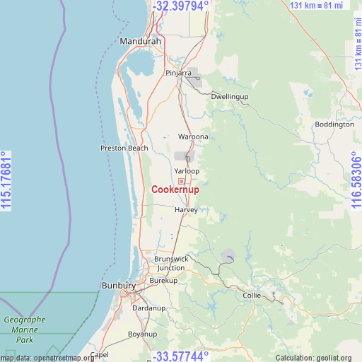
Cookernup GPS coordinates[2]
32° 59' 22.776" South, 115° 52' 47.748" East
| Map corner | latitude | longitude |
|---|---|---|
| Upper-left | -32.39794°, | 115.17681° |
| Center: | -32.98966°, | 115.87993° |
| Lower-right: | -33.57744°, | 116.58306° |
| Map W x H: | 131.1×131.1 km | = 81.5×81.5mi |
| max Lat: | -10.58257° ⇑42.4% North |
| Cookernup: | -32.98966° |
| min Lat: | ⇓57.6% South -43.31423° |
| min Long | Cookernup | max Long |
| 113.53327° | 115.87993° | 153.61246° |
| W 5.9%⇐ | ⇒94.1% E |
Elevation
Elevation of Cookernup is 32 m = 105 ft, and this is 90 m = 295 ft below average elevation for this country.
| Max E: |
1715 m = 5627 ft | 60% |
| Avg. | 122 m = 400 ft | |
| Cookernup | 32 m = 105 ft | |
Min E: |
-2 m = -7 ft | 40% |
See also: Australia elevation on elevation.city.
Geographical zone
Cookernup is located in South temperate zone (between Tropic of Capricorn and the Antarctic Circle). Distance of this Southern Tropic circle is 1062.2 km =660 mi to North.| Distance of | km | miles | from Cookernup |
|---|---|---|---|
| Equator | 3668.1 | 2279.3 | to North |
| Tropic Capricorn | 1062.2 | 660 | to North |
| Antarctic Circle | 3733.1 | 2319.6 | to South |
| South Pole | 6339 | 3938.9 | to South |


Nearby cities:
15 places around Cookernup: (largest is in red/bold)
• Australind
35.7 km =22.2 mi,  205°
205°
• Binningup
24.6 km =15.3 mi,  224°
224°
• Bouvard
37.6 km =23.4 mi,  323°
323°
• Brunswick
27 km =16.8 mi,  183°
183°
• Burekup
35.8 km =22.2 mi,  189°
189°
• Dwellingup
35 km =21.7 mi,  29°
29°
• Eaton
39.8 km =24.7 mi,  204°
204°
• Harvey
10.4 km =6.5 mi,  161°
161°
• Lake Clifton
26.7 km =16.6 mi, 317°
• Leschenault
31.9 km =19.8 mi, 206°
• Millbridge
37.7 km =23.4 mi, 200°
• Pelican Point
40.5 km =25.2 mi, 205°
• Pinjarra
40 km =24.9 mi,  359°
359°
• Roelands
33.2 km =20.6 mi, 190°
• Waroona
16.7 km =10.4 mi,  13°
13°
Sources, notices
• [Note1] Compared only with cities in Australia existing in our database
• [Src1] Map data: © OpenStreetMap contributors (CC-BY-SA)
• [Src2] Other city data from geonames.org with taken over terms of usage.
• [Src3] Geographical zone / Annual Mean Temperature by Robert A. Rohde @ Wikipedia
