Denham geodata
Denham (Western Australia) is a populated place; located in Australia in Australia/Perth (GMT+8) time zone. With population of 1,659 people, there are 3131 cities with bigger population in this country. Compared to other cities in Australia, 88.7% of cities are located further ↓South; 100% of cities are located further →East and 86.8% of cities have higher elevation than Denham. Note1


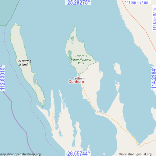
Denham GPS coordinates[2]
25° 55' 36.444" South, 113° 31' 59.772" East
| Map corner | latitude | longitude |
|---|---|---|
| Upper-left | -25.29275°, | 112.83015° |
| Center: | -25.92679°, | 113.53327° |
| Lower-right: | -26.55744°, | 114.2364° |
| Map W x H: | 140.6×140.6 km | = 87.4×87.4mi |
| max Lat: | -10.58257° ⇑11.3% North |
| Denham: | -25.92679° |
| min Lat: | ⇓88.7% South -43.31423° |
| min Long | Denham | max Long |
| 113.53327° | 113.53327° | 153.61246° |
| W 0%⇐ | ⇒100% E |
Elevation
Elevation of Denham is 11 m = 36 ft, and this is 111 m = 364 ft below average elevation for this country.
| Max E: |
1715 m = 5627 ft | 86.8% |
| Avg. | 122 m = 400 ft | |
| Denham | 11 m = 36 ft | |
Min E: |
-2 m = -7 ft | 13.2% |
See also: Australia elevation on elevation.city.
Geographical zone
Denham is located in South temperate zone (between Tropic of Capricorn and the Antarctic Circle). Distance of this Southern Tropic circle is 276.9 km =172.1 mi to North.| Distance of | km | miles | from Denham |
|---|---|---|---|
| Equator | 2882.8 | 1791.3 | to North |
| Tropic Capricorn | 276.9 | 172.1 | to North |
| Antarctic Circle | 4518.4 | 2807.6 | to South |
| South Pole | 7124.3 | 4426.8 | to South |


Nearby cities:
15 places around Denham: (largest is in red/bold)
• Bluff Point
330.5 km =205.4 mi,  161°
161°
• Brockman
116.9 km =72.6 mi,  5°
5°
• Carnarvon
116.8 km =72.6 mi, 6°
• Coral Bay
310.7 km =193.1 mi,  4°
4°
• Drummond Cove
323.5 km =201 mi, 160°
• East Carnarvon
119.1 km =74 mi, 6°
• Glenfield
325.8 km =202.4 mi, 160°
• Kalbarri
208 km =129.2 mi, 162°
• Kingsford
119.3 km =74.1 mi, 7°
• Morgantown
117.5 km =73 mi, 6°
• Northampton
290.8 km =180.7 mi, 157°
• South Carnarvon
115.6 km =71.8 mi, 6°
• Spalding
330.7 km =205.5 mi, 160°
• Sunset Beach
328.6 km =204.2 mi, 160°
• Waggrakine
329.1 km =204.5 mi, 160°
Sources, notices
• [Note1] Compared only with cities in Australia existing in our database
• [Src1] Map data: © OpenStreetMap contributors (CC-BY-SA)
• [Src2] Other city data from geonames.org with taken over terms of usage.
• [Src3] Geographical zone / Annual Mean Temperature by Robert A. Rohde @ Wikipedia
