Coral Bay geodata
Coral Bay (Western Australia) is a populated place; located in Australia in Australia/Perth (GMT+8) time zone. With population of 994 people, there are 3829 cities with bigger population in this country. Compared to other cities in Australia, 92.3% of cities are located further ↓South; 99.9% of cities are located further →East and 93.8% of cities have higher elevation than Coral Bay. Note1


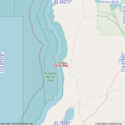
Coral Bay GPS coordinates[2]
23° 8' 26.988" South, 113° 46' 34.68" East
| Map corner | latitude | longitude |
|---|---|---|
| Upper-left | -22.49273°, | 113.07318° |
| Center: | -23.14083°, | 113.7763° |
| Lower-right: | -23.78581°, | 114.47943° |
| Map W x H: | 143.8×143.8 km | = 89.4×89.4mi |
| max Lat: | -10.58257° ⇑7.7% North |
| Coral Bay: | -23.14083° |
| min Lat: | ⇓92.3% South -43.31423° |
| min Long | Coral Bay | max Long |
| 113.53327° | 113.7763° | 153.61246° |
| W 0.1%⇐ | ⇒99.9% E |
Elevation
Elevation of Coral Bay is 7 m = 23 ft, and this is 115 m = 377 ft below average elevation for this country.
| Max E: |
1715 m = 5627 ft | 93.8% |
| Avg. | 122 m = 400 ft | |
| Coral Bay | 7 m = 23 ft | |
Min E: |
-2 m = -7 ft | 6.2% |
See also: Australia elevation on elevation.city.
Geographical zone
Coral Bay is located in South Torrid zone (between Equator and Tropic of Capricorn). Distance of this Southern Tropic circle is 32.9 km =20.4 mi to South.| Distance of | km | miles | from Coral Bay |
|---|---|---|---|
| Equator | 2573 | 1598.8 | to North |
| Tropic Capricorn | 32.9 | 20.4 | to South |
| Antarctic Circle | 4828.2 | 3000.1 | to South |
| South Pole | 7434 | 4619.3 | to South |


Nearby cities:
15 places around Coral Bay: (largest is in red/bold)
• Baynton
409.7 km =254.6 mi,  49°
49°
• Brockman
193.9 km =120.5 mi,  183°
183°
• Carnarvon
194 km =120.5 mi, 183°
• Dampier
409.5 km =254.5 mi, 47°
• Denham
310.7 km =193.1 mi, 184°
• East Carnarvon
191.9 km =119.2 mi, 182°
• Exmouth
139.1 km =86.4 mi,  14°
14°
• Kingsford
191.8 km =119.2 mi, 182°
• Morgantown
193.4 km =120.2 mi, 183°
• Nickol
409.7 km =254.6 mi, 49°
• North West Cape
137.5 km =85.4 mi, 10°
• Onslow
216.3 km =134.4 mi,  39°
39°
• Pannawonica
310.4 km =192.9 mi,  57°
57°
• Paraburdoo
398 km =247.3 mi,  91°
91°
• South Carnarvon
195.2 km =121.3 mi, 183°
Sources, notices
• [Note1] Compared only with cities in Australia existing in our database
• [Src1] Map data: © OpenStreetMap contributors (CC-BY-SA)
• [Src2] Other city data from geonames.org with taken over terms of usage.
• [Src3] Geographical zone / Annual Mean Temperature by Robert A. Rohde @ Wikipedia
