Mount Barker geodata
Mount Barker (South Australia) is a populated place; located in Australia in Australia/Adelaide (GMT+10.5) time zone. With population of 13,583 people, there are 329 cities with bigger population in this country. Compared to other cities in Australia, 72.6% of cities are located further ↑North; 77.1% of cities are located further →East and 88.3% of cities have lower elevation than Mount Barker. Note1


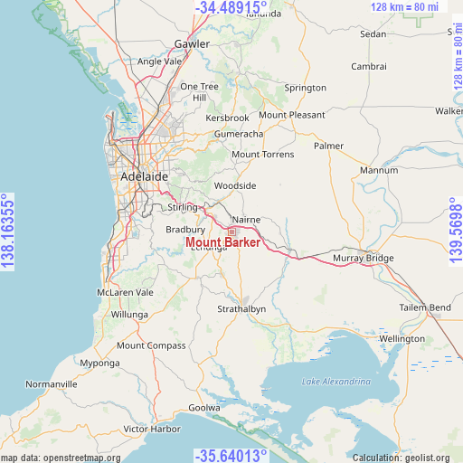
Mount Barker GPS coordinates[2]
35° 4' 0.012" South, 138° 52' 0.012" East
| Map corner | latitude | longitude |
|---|---|---|
| Upper-left | -34.48915°, | 138.16355° |
| Center: | -35.06667°, | 138.86667° |
| Lower-right: | -35.64013°, | 139.5698° |
| Map W x H: | 128×128 km | = 79.5×79.5mi |
| max Lat: | -10.58257° ⇑72.6% North |
| Mount Barker: | -35.06667° |
| min Lat: | ⇓27.4% South -43.31423° |
| min Long | Mount Barker | max Long |
| 113.53327° | 138.86667° | 153.61246° |
| W 22.9%⇐ | ⇒77.1% E |
Elevation
Elevation of Mount Barker is 322 m = 1056 ft, and this is 200 m = 656 ft above average elevation for this country.
| Max E: |
1715 m = 5627 ft | 11.7% |
| Mount Barker | 322 m 1056 ft | |
| Avg. | 122 m = 400 ft | |
Min E: |
-2 m = -7 ft | 88.3% |
See also: Australia elevation on elevation.city.
Geographical zone
Mount Barker is located in South temperate zone (between Tropic of Capricorn and the Antarctic Circle). Distance of this Southern Tropic circle is 1293.1 km =803.5 mi to North.| Distance of | km | miles | from Mount Barker |
|---|---|---|---|
| Equator | 3899 | 2422.7 | to North |
| Tropic Capricorn | 1293.1 | 803.5 | to North |
| Antarctic Circle | 3502.1 | 2176.1 | to South |
| South Pole | 6108 | 3795.3 | to South |


Nearby cities:
15 places around Mount Barker: (largest is in red/bold)
• Aldgate
13.4 km =8.3 mi,  294°
294°
• Balhannah
9.2 km =5.7 mi,  336°
336°
• Bridgewater
10.8 km =6.7 mi,  302°
302°
• Echunga
7.6 km =4.7 mi,  237°
237°
• Hahndorf
6.8 km =4.2 mi,  308°
308°
• Heathfield
14.3 km =8.9 mi, 287°
• Kanmantoo
13.3 km =8.3 mi,  91°
91°
• Little Hampton
2.7 km =1.7 mi,  355°
355°
• Macclesfield
12 km =7.5 mi,  193°
193°
• Meadows
15.8 km =9.8 mi,  216°
216°
• Mylor
10.1 km =6.3 mi, 285°
• Nairne
5.4 km =3.4 mi,  48°
48°
• Oakbank
9.5 km =5.9 mi,  348°
348°
• Stirling
15.2 km =9.4 mi, 298°
• Woodside
12.5 km =7.8 mi,  5°
5°
Sources, notices
• [Note1] Compared only with cities in Australia existing in our database
• [Src1] Map data: © OpenStreetMap contributors (CC-BY-SA)
• [Src2] Other city data from geonames.org with taken over terms of usage.
• [Src3] Geographical zone / Annual Mean Temperature by Robert A. Rohde @ Wikipedia
