Meadows geodata
Meadows (South Australia) is a populated place; located in Australia in Australia/Adelaide (GMT+10.5) time zone. With population of 1,342 people, there are 3429 cities with bigger population in this country. Compared to other cities in Australia, 74.1% of cities are located further ↑North; 77.4% of cities are located further →East and 89.2% of cities have lower elevation than Meadows. Note1


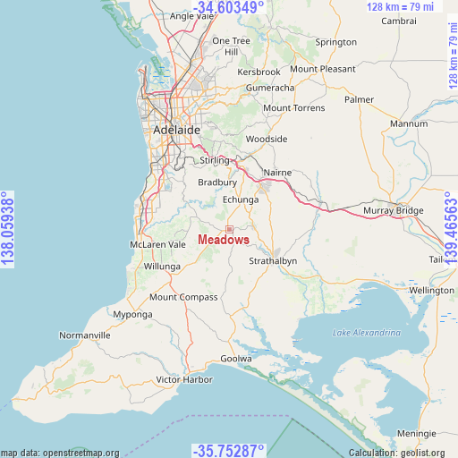
Meadows GPS coordinates[2]
35° 10' 48.756" South, 138° 45' 45" East
| Map corner | latitude | longitude |
|---|---|---|
| Upper-left | -34.60349°, | 138.05938° |
| Center: | -35.18021°, | 138.7625° |
| Lower-right: | -35.75287°, | 139.46563° |
| Map W x H: | 127.8×127.8 km | = 79.4×79.4mi |
| max Lat: | -10.58257° ⇑74.1% North |
| Meadows: | -35.18021° |
| min Lat: | ⇓25.9% South -43.31423° |
| min Long | Meadows | max Long |
| 113.53327° | 138.7625° | 153.61246° |
| W 22.6%⇐ | ⇒77.4% E |
Elevation
Elevation of Meadows is 353 m = 1158 ft, and this is 231 m = 758 ft above average elevation for this country.
| Max E: |
1715 m = 5627 ft | 10.8% |
| Meadows | 353 m 1158 ft | |
| Avg. | 122 m = 400 ft | |
Min E: |
-2 m = -7 ft | 89.2% |
See also: Australia elevation on elevation.city.
Geographical zone
Meadows is located in South temperate zone (between Tropic of Capricorn and the Antarctic Circle). Distance of this Southern Tropic circle is 1305.8 km =811.4 mi to North.| Distance of | km | miles | from Meadows |
|---|---|---|---|
| Equator | 3911.7 | 2430.6 | to North |
| Tropic Capricorn | 1305.8 | 811.4 | to North |
| Antarctic Circle | 3489.5 | 2168.3 | to South |
| South Pole | 6095.4 | 3787.5 | to South |


Nearby cities:
15 places around Meadows: (largest is in red/bold)
• Aldgate
18.4 km =11.4 mi,  351°
351°
• Chandlers Hill
16.8 km =10.4 mi,  308°
308°
• Cherry Gardens
15.8 km =9.8 mi,  325°
325°
• Clarendon
13.7 km =8.5 mi,  301°
301°
• Echunga
9 km =5.6 mi,  19°
19°
• Hahndorf
17.4 km =10.8 mi,  13°
13°
• Heathfield
17.4 km =10.8 mi, 346°
• Ironbank
16.2 km =10.1 mi, 333°
• Kangarilla
9.9 km =6.2 mi,  290°
290°
• Little Hampton
17.9 km =11.1 mi,  31°
31°
• Macclesfield
6.7 km =4.2 mi,  82°
82°
• McLaren Flat
16.8 km =10.4 mi,  256°
256°
• Mount Barker
15.8 km =9.8 mi,  36°
36°
• Mylor
15.3 km =9.5 mi,  358°
358°
• Strathalbyn
14.8 km =9.2 mi,  126°
126°
Sources, notices
• [Note1] Compared only with cities in Australia existing in our database
• [Src1] Map data: © OpenStreetMap contributors (CC-BY-SA)
• [Src2] Other city data from geonames.org with taken over terms of usage.
• [Src3] Geographical zone / Annual Mean Temperature by Robert A. Rohde @ Wikipedia
