Mylor geodata
Mylor (South Australia) is a populated place; located in Australia in Australia/Adelaide (GMT+10.5) time zone. With population of 1,091 people, there are 3708 cities with bigger population in this country. Compared to other cities in Australia, 72.4% of cities are located further ↑North; 77.5% of cities are located further →East and 88.1% of cities have lower elevation than Mylor. Note1


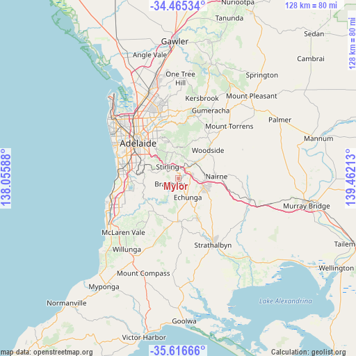
Mylor GPS coordinates[2]
35° 2' 34.908" South, 138° 45' 32.4" East
| Map corner | latitude | longitude |
|---|---|---|
| Upper-left | -34.46534°, | 138.05588° |
| Center: | -35.04303°, | 138.759° |
| Lower-right: | -35.61666°, | 139.46213° |
| Map W x H: | 128×128 km | = 79.5×79.5mi |
| max Lat: | -10.58257° ⇑72.4% North |
| Mylor: | -35.04303° |
| min Lat: | ⇓27.6% South -43.31423° |
| min Long | Mylor | max Long |
| 113.53327° | 138.759° | 153.61246° |
| W 22.5%⇐ | ⇒77.5% E |
Elevation
Elevation of Mylor is 316 m = 1037 ft, and this is 194 m = 636 ft above average elevation for this country.
| Max E: |
1715 m = 5627 ft | 11.9% |
| Mylor | 316 m 1037 ft | |
| Avg. | 122 m = 400 ft | |
Min E: |
-2 m = -7 ft | 88.1% |
See also: Australia elevation on elevation.city.
Geographical zone
Mylor is located in South temperate zone (between Tropic of Capricorn and the Antarctic Circle). Distance of this Southern Tropic circle is 1290.5 km =801.9 mi to North.| Distance of | km | miles | from Mylor |
|---|---|---|---|
| Equator | 3896.4 | 2421.1 | to North |
| Tropic Capricorn | 1290.5 | 801.9 | to North |
| Antarctic Circle | 3504.8 | 2177.8 | to South |
| South Pole | 6110.6 | 3796.9 | to South |


Nearby cities:
15 places around Mylor: (largest is in red/bold)
• Aldgate
3.7 km =2.3 mi,  321°
321°
• Balhannah
8.4 km =5.2 mi,  46°
46°
• Bridgewater
3.3 km =2.1 mi,  11°
11°
• Cherry Gardens
9 km =5.6 mi,  255°
255°
• Crafers
7.2 km =4.5 mi,  311°
311°
• Crafers West
9.1 km =5.7 mi, 309°
• Echunga
7.5 km =4.7 mi,  153°
153°
• Hahndorf
4.7 km =2.9 mi,  70°
70°
• Heathfield
4.1 km =2.5 mi,  293°
293°
• Ironbank
6.9 km =4.3 mi, 263°
• Little Hampton
9.6 km =6 mi,  89°
89°
• Stirling
5.8 km =3.6 mi, 321°
• Summertown
9.6 km =6 mi,  344°
344°
• Upper Sturt
7.5 km =4.7 mi, 293°
• Uraidla
9.8 km =6.1 mi,  352°
352°
Sources, notices
• [Note1] Compared only with cities in Australia existing in our database
• [Src1] Map data: © OpenStreetMap contributors (CC-BY-SA)
• [Src2] Other city data from geonames.org with taken over terms of usage.
• [Src3] Geographical zone / Annual Mean Temperature by Robert A. Rohde @ Wikipedia
