Bridgewater geodata
Bridgewater (South Australia) is a populated place; located in Australia in Australia/Adelaide (GMT+10.5) time zone. With population of 3,469 people, there are 2001 cities with bigger population in this country. Compared to other cities in Australia, 71.6% of cities are located further ↑North; 77.4% of cities are located further →East and 91% of cities have lower elevation than Bridgewater. Note1


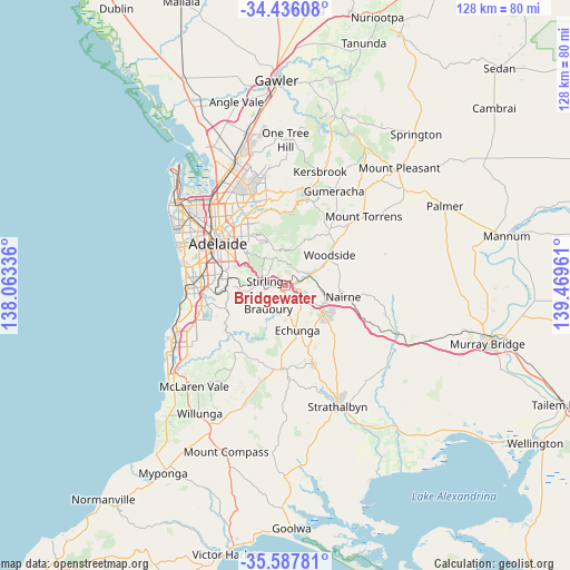
Bridgewater GPS coordinates[2]
35° 0' 50.292" South, 138° 45' 59.328" East
| Map corner | latitude | longitude |
|---|---|---|
| Upper-left | -34.43608°, | 138.06336° |
| Center: | -35.01397°, | 138.76648° |
| Lower-right: | -35.58781°, | 139.46961° |
| Map W x H: | 128.1×128.1 km | = 79.6×79.6mi |
| max Lat: | -10.58257° ⇑71.6% North |
| Bridgewater: | -35.01397° |
| min Lat: | ⇓28.4% South -43.31423° |
| min Long | Bridgewater | max Long |
| 113.53327° | 138.76648° | 153.61246° |
| W 22.6%⇐ | ⇒77.4% E |
Elevation
Elevation of Bridgewater is 414 m = 1358 ft, and this is 292 m = 958 ft above average elevation for this country.
| Max E: |
1715 m = 5627 ft | 9% |
| Bridgewater | 414 m 1358 ft | |
| Avg. | 122 m = 400 ft | |
Min E: |
-2 m = -7 ft | 91% |
See also: Australia elevation on elevation.city.
Geographical zone
Bridgewater is located in South temperate zone (between Tropic of Capricorn and the Antarctic Circle). Distance of this Southern Tropic circle is 1287.3 km =799.9 mi to North.| Distance of | km | miles | from Bridgewater |
|---|---|---|---|
| Equator | 3893.2 | 2419.1 | to North |
| Tropic Capricorn | 1287.3 | 799.9 | to North |
| Antarctic Circle | 3508 | 2179.8 | to South |
| South Pole | 6113.9 | 3799 | to South |


Nearby cities:
15 places around Bridgewater: (largest is in red/bold)
• Aldgate
3 km =1.9 mi,  264°
264°
• Balhannah
6 km =3.7 mi,  64°
64°
• Crafers
6.3 km =3.9 mi,  284°
284°
• Crafers West
8.1 km =5 mi,  288°
288°
• Echunga
10.3 km =6.4 mi,  164°
164°
• Hahndorf
4.1 km =2.5 mi,  113°
113°
• Heathfield
4.8 km =3 mi,  250°
250°
• Ironbank
8.6 km =5.3 mi,  242°
242°
• Little Hampton
9.4 km =5.8 mi, 109°
• Mylor
3.3 km =2.1 mi,  191°
191°
• Oakbank
7.9 km =4.9 mi, 64°
• Stirling
4.5 km =2.8 mi, 287°
• Summertown
6.9 km =4.3 mi,  332°
332°
• Upper Sturt
7.6 km =4.7 mi,  267°
267°
• Uraidla
6.8 km =4.2 mi,  342°
342°
Sources, notices
• [Note1] Compared only with cities in Australia existing in our database
• [Src1] Map data: © OpenStreetMap contributors (CC-BY-SA)
• [Src2] Other city data from geonames.org with taken over terms of usage.
• [Src3] Geographical zone / Annual Mean Temperature by Robert A. Rohde @ Wikipedia
