Stirling geodata
Stirling (South Australia) is a populated place; located in Australia in Australia/Adelaide (GMT+10.5) time zone. With population of 2,867 people, there are 2336 cities with bigger population in this country. Compared to other cities in Australia, 71.3% of cities are located further ↑North; 77.9% of cities are located further →East and 91.4% of cities have lower elevation than Stirling. Note1


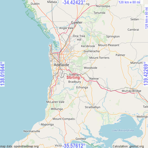
Stirling GPS coordinates[2]
35° 0' 7.92" South, 138° 43' 10.416" East
| Map corner | latitude | longitude |
|---|---|---|
| Upper-left | -34.42423°, | 138.01644° |
| Center: | -35.0022°, | 138.71956° |
| Lower-right: | -35.57612°, | 139.42269° |
| Map W x H: | 128.1×128.1 km | = 79.6×79.6mi |
| max Lat: | -10.58257° ⇑71.3% North |
| Stirling: | -35.0022° |
| min Lat: | ⇓28.7% South -43.31423° |
| min Long | Stirling | max Long |
| 113.53327° | 138.71956° | 153.61246° |
| W 22.1%⇐ | ⇒77.9% E |
Elevation
Elevation of Stirling is 424 m = 1391 ft, and this is 302 m = 991 ft above average elevation for this country.
| Max E: |
1715 m = 5627 ft | 8.6% |
| Stirling | 424 m 1391 ft | |
| Avg. | 122 m = 400 ft | |
Min E: |
-2 m = -7 ft | 91.4% |
See also: Australia elevation on elevation.city.
Geographical zone
Stirling is located in South temperate zone (between Tropic of Capricorn and the Antarctic Circle). Distance of this Southern Tropic circle is 1286 km =799.1 mi to North.| Distance of | km | miles | from Stirling |
|---|---|---|---|
| Equator | 3891.9 | 2418.3 | to North |
| Tropic Capricorn | 1286 | 799.1 | to North |
| Antarctic Circle | 3509.3 | 2180.6 | to South |
| South Pole | 6115.2 | 3799.8 | to South |


Nearby cities:
15 places around Stirling: (largest is in red/bold)
• Aldgate
2 km =1.2 mi,  142°
142°
• Beaumont
7.9 km =4.9 mi,  318°
318°
• Bridgewater
4.5 km =2.8 mi,  107°
107°
• Crafers
1.8 km =1.1 mi,  277°
277°
• Crafers West
3.6 km =2.2 mi,  289°
289°
• Glen Osmond
8 km =5 mi,  306°
306°
• Hawthorndene
8.4 km =5.2 mi,  254°
254°
• Heathfield
2.9 km =1.8 mi,  184°
184°
• Ironbank
6.3 km =3.9 mi,  211°
211°
• Mylor
5.8 km =3.6 mi, 141°
• Springfield
8.4 km =5.2 mi, 288°
• Summertown
4.9 km =3 mi,  12°
12°
• Upper Sturt
3.7 km =2.3 mi,  244°
244°
• Uraidla
5.6 km =3.5 mi,  23°
23°
• Urrbrae
8.1 km =5 mi,  299°
299°
Sources, notices
• [Note1] Compared only with cities in Australia existing in our database
• [Src1] Map data: © OpenStreetMap contributors (CC-BY-SA)
• [Src2] Other city data from geonames.org with taken over terms of usage.
• [Src3] Geographical zone / Annual Mean Temperature by Robert A. Rohde @ Wikipedia
