Lewiston geodata
Lewiston (South Australia) is a populated place; located in Australia in Australia/Adelaide (GMT+10.5) time zone. With population of 3,009 people, there are 2252 cities with bigger population in this country. Compared to other cities in Australia, 64.1% of cities are located further ↑North; 81.7% of cities are located further →East and 67.2% of cities have higher elevation than Lewiston. Note1


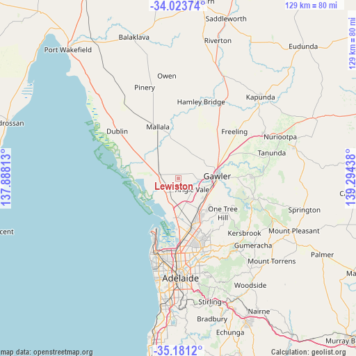
Lewiston GPS coordinates[2]
34° 36' 16.164" South, 138° 35' 28.5" East
| Map corner | latitude | longitude |
|---|---|---|
| Upper-left | -34.02374°, | 137.88813° |
| Center: | -34.60449°, | 138.59125° |
| Lower-right: | -35.1812°, | 139.29438° |
| Map W x H: | 128.7×128.7 km | = 80×80mi |
| max Lat: | -10.58257° ⇑64.1% North |
| Lewiston: | -34.60449° |
| min Lat: | ⇓35.9% South -43.31423° |
| min Long | Lewiston | max Long |
| 113.53327° | 138.59125° | 153.61246° |
| W 18.3%⇐ | ⇒81.7% E |
Elevation
Elevation of Lewiston is 25 m = 82 ft, and this is 97 m = 318 ft below average elevation for this country.
| Max E: |
1715 m = 5627 ft | 67.2% |
| Avg. | 122 m = 400 ft | |
| Lewiston | 25 m = 82 ft | |
Min E: |
-2 m = -7 ft | 32.8% |
See also: Australia elevation on elevation.city.
Geographical zone
Lewiston is located in South temperate zone (between Tropic of Capricorn and the Antarctic Circle). Distance of this Southern Tropic circle is 1241.7 km =771.6 mi to North.| Distance of | km | miles | from Lewiston |
|---|---|---|---|
| Equator | 3847.7 | 2390.8 | to North |
| Tropic Capricorn | 1241.7 | 771.6 | to North |
| Antarctic Circle | 3553.5 | 2208 | to South |
| South Pole | 6159.4 | 3827.3 | to South |


Nearby cities:
15 places around Lewiston: (largest is in red/bold)
• Andrews Farm
10.3 km =6.4 mi,  140°
140°
• Angle Vale
6.5 km =4 mi,  128°
128°
• Davoren Park
11.9 km =7.4 mi, 143°
• Evanston Gardens
12.1 km =7.5 mi,  99°
99°
• Hillier
7.6 km =4.7 mi,  112°
112°
• Kudla
11 km =6.8 mi, 112°
• MacDonald Park
7.7 km =4.8 mi, 141°
• Munno Para
12.3 km =7.6 mi,  124°
124°
• Munno Para West
10.6 km =6.6 mi, 129°
• Penfield
11 km =6.8 mi,  156°
156°
• Smithfield
12.2 km =7.6 mi, 136°
• Smithfield Plains
11.3 km =7 mi, 135°
• Two Wells
7.2 km =4.5 mi,  279°
279°
• Virginia
7.4 km =4.6 mi,  202°
202°
• Waterloo Corner
12.5 km =7.8 mi,  183°
183°
Sources, notices
• [Note1] Compared only with cities in Australia existing in our database
• [Src1] Map data: © OpenStreetMap contributors (CC-BY-SA)
• [Src2] Other city data from geonames.org with taken over terms of usage.
• [Src3] Geographical zone / Annual Mean Temperature by Robert A. Rohde @ Wikipedia
