Two Wells geodata
Two Wells (South Australia) is a populated place; located in Australia in Australia/Adelaide (GMT+10.5) time zone. With population of 2,515 people, there are 2562 cities with bigger population in this country. Compared to other cities in Australia, 64% of cities are located further ↑North; 84.2% of cities are located further →East and 79% of cities have higher elevation than Two Wells. Note1


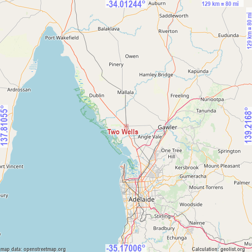
Two Wells GPS coordinates[2]
34° 35' 35.772" South, 138° 30' 49.212" East
| Map corner | latitude | longitude |
|---|---|---|
| Upper-left | -34.01244°, | 137.81055° |
| Center: | -34.59327°, | 138.51367° |
| Lower-right: | -35.17006°, | 139.2168° |
| Map W x H: | 128.7×128.7 km | = 80×80mi |
| max Lat: | -10.58257° ⇑64% North |
| Two Wells: | -34.59327° |
| min Lat: | ⇓36% South -43.31423° |
| min Long | Two Wells | max Long |
| 113.53327° | 138.51367° | 153.61246° |
| W 15.8%⇐ | ⇒84.2% E |
Elevation
Elevation of Two Wells is 16 m = 52 ft, and this is 106 m = 348 ft below average elevation for this country.
| Max E: |
1715 m = 5627 ft | 79% |
| Avg. | 122 m = 400 ft | |
| Two Wells | 16 m = 52 ft | |
Min E: |
-2 m = -7 ft | 21% |
See also: Australia elevation on elevation.city.
Geographical zone
Two Wells is located in South temperate zone (between Tropic of Capricorn and the Antarctic Circle). Distance of this Southern Tropic circle is 1240.5 km =770.8 mi to North.| Distance of | km | miles | from Two Wells |
|---|---|---|---|
| Equator | 3846.4 | 2390 | to North |
| Tropic Capricorn | 1240.5 | 770.8 | to North |
| Antarctic Circle | 3554.8 | 2208.8 | to South |
| South Pole | 6160.7 | 3828.1 | to South |


Nearby cities:
15 places around Two Wells: (largest is in red/bold)
• Andrews Farm
16.4 km =10.2 mi,  124°
124°
• Angle Vale
13.2 km =8.2 mi,  113°
113°
• Burton
17.6 km =10.9 mi,  152°
152°
• Davoren Park
17.8 km =11.1 mi,  127°
127°
• Direk
16.4 km =10.2 mi, 150°
• Hillier
14.7 km =9.1 mi, 106°
• Kudla
18.1 km =11.2 mi, 107°
• Lewiston
7.2 km =4.5 mi,  99°
99°
• MacDonald Park
13.9 km =8.6 mi, 121°
• Mallala
17.3 km =10.7 mi,  358°
358°
• Munno Para West
17.2 km =10.7 mi, 117°
• Penfield
16.2 km =10.1 mi, 134°
• Smithfield Plains
17.6 km =10.9 mi, 121°
• Virginia
9.2 km =5.7 mi, 152°
• Waterloo Corner
15.1 km =9.4 mi,  155°
155°
Sources, notices
• [Note1] Compared only with cities in Australia existing in our database
• [Src1] Map data: © OpenStreetMap contributors (CC-BY-SA)
• [Src2] Other city data from geonames.org with taken over terms of usage.
• [Src3] Geographical zone / Annual Mean Temperature by Robert A. Rohde @ Wikipedia
