Fremantle geodata
Fremantle (Western Australia) is a section of populated place; located in Australia in Australia/Perth (GMT+8) time zone. With population of 8,616 people, there are 745 cities with bigger population in this country. Compared to other cities in Australia, 64.1% of cities are located further ↓South; 97.6% of cities are located further →East and 93.8% of cities have higher elevation than Fremantle. Note1


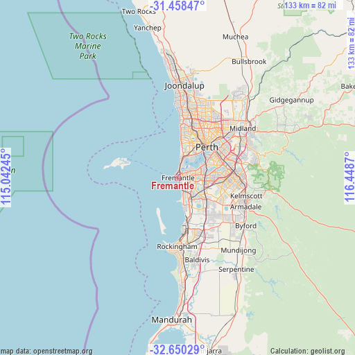
Fremantle GPS coordinates[2]
32° 3' 22.752" South, 115° 44' 44.052" East
| Map corner | latitude | longitude |
|---|---|---|
| Upper-left | -31.45847°, | 115.04245° |
| Center: | -32.05632°, | 115.74557° |
| Lower-right: | -32.65029°, | 116.4487° |
| Map W x H: | 132.5×132.5 km | = 82.3×82.3mi |
| max Lat: | -10.58257° ⇑35.9% North |
| Fremantle: | -32.05632° |
| min Lat: | ⇓64.1% South -43.31423° |
| min Long | Fremantle | max Long |
| 113.53327° | 115.74557° | 153.61246° |
| W 2.4%⇐ | ⇒97.6% E |
Elevation
Elevation of Fremantle is 7 m = 23 ft, and this is 115 m = 377 ft below average elevation for this country.
| Max E: |
1715 m = 5627 ft | 93.8% |
| Avg. | 122 m = 400 ft | |
| Fremantle | 7 m = 23 ft | |
Min E: |
-2 m = -7 ft | 6.2% |
See also: Australia elevation on elevation.city.
Geographical zone
Fremantle is located in South temperate zone (between Tropic of Capricorn and the Antarctic Circle). Distance of this Southern Tropic circle is 958.4 km =595.5 mi to North.| Distance of | km | miles | from Fremantle |
|---|---|---|---|
| Equator | 3564.3 | 2214.8 | to North |
| Tropic Capricorn | 958.4 | 595.5 | to North |
| Antarctic Circle | 3836.8 | 2384.1 | to South |
| South Pole | 6442.7 | 4003.3 | to South |


Nearby cities:
15 places around Fremantle: (largest is in red/bold)
• Beaconsfield
2.1 km =1.3 mi,  125°
125°
• Bicton
4.8 km =3 mi,  48°
48°
• East Fremantle
2.9 km =1.8 mi, 45°
• Hamilton Hill
4.5 km =2.8 mi, 134°
• Hilton
3.4 km =2.1 mi,  101°
101°
• Melville
5.5 km =3.4 mi,  71°
71°
• Mosman Park
5.9 km =3.7 mi,  16°
16°
• North Coogee
4.5 km =2.8 mi,  162°
162°
• North Fremantle
2.6 km =1.6 mi,  9°
9°
• Palmyra
4 km =2.5 mi, 71°
• Samson
5.1 km =3.2 mi,  107°
107°
• South Fremantle
1.7 km =1.1 mi,  149°
149°
• Spearwood
6.2 km =3.9 mi, 150°
• White Gum Valley
2.4 km =1.5 mi, 100°
• Willagee
5.7 km =3.5 mi,  85°
85°
Sources, notices
• [Note1] Compared only with cities in Australia existing in our database
• [Src1] Map data: © OpenStreetMap contributors (CC-BY-SA)
• [Src2] Other city data from geonames.org with taken over terms of usage.
• [Src3] Geographical zone / Annual Mean Temperature by Robert A. Rohde @ Wikipedia
