Melville geodata
Melville (Western Australia) is a section of populated place; located in Australia in Australia/Perth (GMT+8) time zone. With population of 5,583 people, there are 1319 cities with bigger population in this country. Compared to other cities in Australia, 64.4% of cities are located further ↓South; 96% of cities are located further →East and 52.8% of cities have lower elevation than Melville. Note1


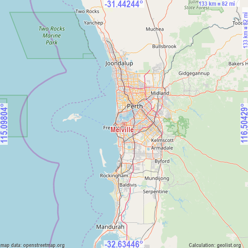
Melville GPS coordinates[2]
32° 2' 25.404" South, 115° 48' 4.176" East
| Map corner | latitude | longitude |
|---|---|---|
| Upper-left | -31.44244°, | 115.09804° |
| Center: | -32.04039°, | 115.80116° |
| Lower-right: | -32.63446°, | 116.50429° |
| Map W x H: | 132.5×132.5 km | = 82.3×82.3mi |
| max Lat: | -10.58257° ⇑35.6% North |
| Melville: | -32.04039° |
| min Lat: | ⇓64.4% South -43.31423° |
| min Long | Melville | max Long |
| 113.53327° | 115.80116° | 153.61246° |
| W 4%⇐ | ⇒96% E |
Elevation
Elevation of Melville is 49 m = 161 ft, and this is 73 m = 240 ft below average elevation for this country.
| Max E: |
1715 m = 5627 ft | 47.2% |
| Avg. | 122 m = 400 ft | |
| Melville | 49 m = 161 ft | |
Min E: |
-2 m = -7 ft | 52.8% |
See also: Australia elevation on elevation.city.
Geographical zone
Melville is located in South temperate zone (between Tropic of Capricorn and the Antarctic Circle). Distance of this Southern Tropic circle is 956.6 km =594.4 mi to North.| Distance of | km | miles | from Melville |
|---|---|---|---|
| Equator | 3562.6 | 2213.7 | to North |
| Tropic Capricorn | 956.6 | 594.4 | to North |
| Antarctic Circle | 3838.6 | 2385.2 | to South |
| South Pole | 6444.5 | 4004.4 | to South |


Nearby cities:
15 places around Melville: (largest is in red/bold)
• Alfred Cove
1.3 km =0.8 mi,  53°
53°
• Applecross
4 km =2.5 mi, 48°
• Ardross
3.6 km =2.2 mi,  65°
65°
• Attadale
1.7 km =1.1 mi,  2°
2°
• Bicton
2.2 km =1.4 mi,  309°
309°
• Booragoon
3.1 km =1.9 mi,  88°
88°
• East Fremantle
3.2 km =2 mi,  274°
274°
• Hilton
3.1 km =1.9 mi,  218°
218°
• Kardinya
3.1 km =1.9 mi,  155°
155°
• Myaree
1.6 km =1 mi, 88°
• Palmyra
1.5 km =0.9 mi,  250°
250°
• Samson
3.3 km =2.1 mi,  185°
185°
• White Gum Valley
3.6 km =2.2 mi,  232°
232°
• Willagee
1.3 km =0.8 mi, 163°
• Winthrop
3 km =1.9 mi,  115°
115°
Sources, notices
• [Note1] Compared only with cities in Australia existing in our database
• [Src1] Map data: © OpenStreetMap contributors (CC-BY-SA)
• [Src2] Other city data from geonames.org with taken over terms of usage.
• [Src3] Geographical zone / Annual Mean Temperature by Robert A. Rohde @ Wikipedia
