Kangarilla geodata
Kangarilla (South Australia) is a section of populated place; located in Australia in Australia/Adelaide (GMT+10.5) time zone. With population of 881 people, there are 4000 cities with bigger population in this country. Compared to other cities in Australia, 73.6% of cities are located further ↑North; 79.3% of cities are located further →East and 81.4% of cities have lower elevation than Kangarilla. Note1


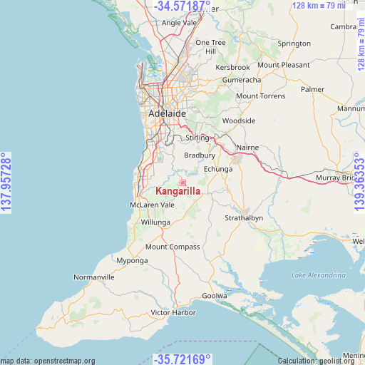
Kangarilla GPS coordinates[2]
35° 8' 55.716" South, 138° 39' 37.44" East
| Map corner | latitude | longitude |
|---|---|---|
| Upper-left | -34.57187°, | 137.95728° |
| Center: | -35.14881°, | 138.6604° |
| Lower-right: | -35.72169°, | 139.36353° |
| Map W x H: | 127.8×127.8 km | = 79.4×79.4mi |
| max Lat: | -10.58257° ⇑73.6% North |
| Kangarilla: | -35.14881° |
| min Lat: | ⇓26.4% South -43.31423° |
| min Long | Kangarilla | max Long |
| 113.53327° | 138.6604° | 153.61246° |
| W 20.7%⇐ | ⇒79.3% E |
Elevation
Elevation of Kangarilla is 196 m = 643 ft, and this is 74 m = 243 ft above average elevation for this country.
| Max E: |
1715 m = 5627 ft | 18.6% |
| Kangarilla | 196 m 643 ft | |
| Avg. | 122 m = 400 ft | |
Min E: |
-2 m = -7 ft | 81.4% |
See also: Australia elevation on elevation.city.
Geographical zone
Kangarilla is located in South temperate zone (between Tropic of Capricorn and the Antarctic Circle). Distance of this Southern Tropic circle is 1302.3 km =809.2 mi to North.| Distance of | km | miles | from Kangarilla |
|---|---|---|---|
| Equator | 3908.2 | 2428.4 | to North |
| Tropic Capricorn | 1302.3 | 809.2 | to North |
| Antarctic Circle | 3493 | 2170.4 | to South |
| South Pole | 6098.9 | 3789.7 | to South |


Nearby cities:
15 places around Kangarilla: (largest is in red/bold)
• Aberfoyle Park
10.2 km =6.3 mi,  322°
322°
• Chandlers Hill
8 km =5 mi,  330°
330°
• Cherry Gardens
9.5 km =5.9 mi,  1°
1°
• Clarendon
4.3 km =2.7 mi, 325°
• Coromandel Valley
11.7 km =7.3 mi,  340°
340°
• Craigburn Farm
13.1 km =8.1 mi, 337°
• Hackham
12.3 km =7.6 mi,  266°
266°
• Ironbank
11.2 km =7 mi,  10°
10°
• McLaren Flat
10.3 km =6.4 mi,  222°
222°
• McLaren Vale
13.2 km =8.2 mi,  233°
233°
• Meadows
9.9 km =6.2 mi,  110°
110°
• Old Reynella
12.6 km =7.8 mi,  293°
293°
• Onkaparinga Hills
8.6 km =5.3 mi,  280°
280°
• Reynella East
11.3 km =7 mi,  304°
304°
• Woodcroft
10.3 km =6.4 mi, 300°
Sources, notices
• [Note1] Compared only with cities in Australia existing in our database
• [Src1] Map data: © OpenStreetMap contributors (CC-BY-SA)
• [Src2] Other city data from geonames.org with taken over terms of usage.
• [Src3] Geographical zone / Annual Mean Temperature by Robert A. Rohde @ Wikipedia
