Ironbank geodata
Ironbank (South Australia) is a populated place; located in Australia in Australia/Adelaide (GMT+10.5) time zone. With population of 504 people, there are 4868 cities with bigger population in this country. Compared to other cities in Australia, 72.5% of cities are located further ↑North; 78.5% of cities are located further →East and 90.7% of cities have lower elevation than Ironbank. Note1


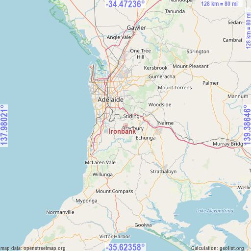
Ironbank GPS coordinates[2]
35° 3' 0" South, 138° 40' 59.988" East
| Map corner | latitude | longitude |
|---|---|---|
| Upper-left | -34.47236°, | 137.98021° |
| Center: | -35.05°, | 138.68333° |
| Lower-right: | -35.62358°, | 139.38646° |
| Map W x H: | 128×128 km | = 79.5×79.5mi |
| max Lat: | -10.58257° ⇑72.5% North |
| Ironbank: | -35.05° |
| min Lat: | ⇓27.5% South -43.31423° |
| min Long | Ironbank | max Long |
| 113.53327° | 138.68333° | 153.61246° |
| W 21.5%⇐ | ⇒78.5% E |
Elevation
Elevation of Ironbank is 402 m = 1319 ft, and this is 280 m = 919 ft above average elevation for this country.
| Max E: |
1715 m = 5627 ft | 9.3% |
| Ironbank | 402 m 1319 ft | |
| Avg. | 122 m = 400 ft | |
Min E: |
-2 m = -7 ft | 90.7% |
See also: Australia elevation on elevation.city.
Geographical zone
Ironbank is located in South temperate zone (between Tropic of Capricorn and the Antarctic Circle). Distance of this Southern Tropic circle is 1291.3 km =802.4 mi to North.| Distance of | km | miles | from Ironbank |
|---|---|---|---|
| Equator | 3897.2 | 2421.6 | to North |
| Tropic Capricorn | 1291.3 | 802.4 | to North |
| Antarctic Circle | 3504 | 2177.3 | to South |
| South Pole | 6109.9 | 3796.5 | to South |


Nearby cities:
15 places around Ironbank: (largest is in red/bold)
• Aldgate
5.9 km =3.7 mi,  50°
50°
• Belair
8.1 km =5 mi,  315°
315°
• Blackwood
7 km =4.3 mi,  296°
296°
• Chandlers Hill
7.3 km =4.5 mi,  236°
236°
• Cherry Gardens
2.4 km =1.5 mi,  231°
231°
• Coromandel Valley
6.1 km =3.8 mi,  270°
270°
• Crafers
5.8 km =3.6 mi,  15°
15°
• Crafers West
6.5 km =4 mi,  358°
358°
• Craigburn Farm
7.2 km =4.5 mi,  278°
278°
• Glenalta
7 km =4.3 mi,  311°
311°
• Hawthorndene
5.7 km =3.5 mi, 302°
• Heathfield
3.9 km =2.4 mi, 52°
• Mylor
6.9 km =4.3 mi,  83°
83°
• Stirling
6.3 km =3.9 mi,  31°
31°
• Upper Sturt
3.7 km =2.3 mi,  0°
0°
Sources, notices
• [Note1] Compared only with cities in Australia existing in our database
• [Src1] Map data: © OpenStreetMap contributors (CC-BY-SA)
• [Src2] Other city data from geonames.org with taken over terms of usage.
• [Src3] Geographical zone / Annual Mean Temperature by Robert A. Rohde @ Wikipedia
