Australind geodata
Australind (Western Australia) is a section of populated place; located in Australia in Australia/Perth (GMT+8) time zone. With population of 13,940 people, there are 316 cities with bigger population in this country. Compared to other cities in Australia, 55.6% of cities are located further ↓South; 98.1% of cities are located further →East and 91.8% of cities have higher elevation than Australind. Note1


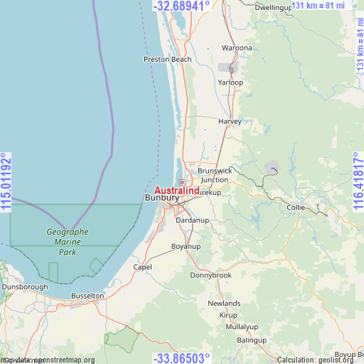
Australind GPS coordinates[2]
33° 16' 45.12" South, 115° 42' 54.144" East
| Map corner | latitude | longitude |
|---|---|---|
| Upper-left | -32.68941°, | 115.01192° |
| Center: | -33.2792°, | 115.71504° |
| Lower-right: | -33.86503°, | 116.41817° |
| Map W x H: | 130.7×130.7 km | = 81.2×81.2mi |
| max Lat: | -10.58257° ⇑44.4% North |
| Australind: | -33.2792° |
| min Lat: | ⇓55.6% South -43.31423° |
| min Long | Australind | max Long |
| 113.53327° | 115.71504° | 153.61246° |
| W 1.9%⇐ | ⇒98.1% E |
Elevation
Elevation of Australind is 8 m = 26 ft, and this is 114 m = 374 ft below average elevation for this country.
| Max E: |
1715 m = 5627 ft | 91.8% |
| Avg. | 122 m = 400 ft | |
| Australind | 8 m = 26 ft | |
Min E: |
-2 m = -7 ft | 8.2% |
See also: Australia elevation on elevation.city.
Geographical zone
Australind is located in South temperate zone (between Tropic of Capricorn and the Antarctic Circle). Distance of this Southern Tropic circle is 1094.4 km =680 mi to North.| Distance of | km | miles | from Australind |
|---|---|---|---|
| Equator | 3700.3 | 2299.3 | to North |
| Tropic Capricorn | 1094.4 | 680 | to North |
| Antarctic Circle | 3700.9 | 2299.6 | to South |
| South Pole | 6306.8 | 3918.9 | to South |


Nearby cities:
15 places around Australind: (largest is in red/bold)
• Bunbury
8.7 km =5.4 mi,  232°
232°
• Burekup
9.7 km =6 mi,  108°
108°
• Carey Park
9.9 km =6.2 mi,  218°
218°
• College Grove
11.9 km =7.4 mi,  205°
205°
• Dardanup West
12 km =7.5 mi,  173°
173°
• East Bunbury
8.1 km =5 mi, 218°
• Eaton
4.3 km =2.7 mi,  192°
192°
• Glen Iris
7.5 km =4.7 mi, 210°
• Leschenault
3.9 km =2.4 mi,  13°
13°
• Millbridge
3.5 km =2.2 mi,  148°
148°
• Pelican Point
4.8 km =3 mi, 205°
• Roelands
9.5 km =5.9 mi,  92°
92°
• South Bunbury
10.8 km =6.7 mi, 224°
• Usher
13.7 km =8.5 mi, 215°
• Withers
12.6 km =7.8 mi, 218°
Sources, notices
• [Note1] Compared only with cities in Australia existing in our database
• [Src1] Map data: © OpenStreetMap contributors (CC-BY-SA)
• [Src2] Other city data from geonames.org with taken over terms of usage.
• [Src3] Geographical zone / Annual Mean Temperature by Robert A. Rohde @ Wikipedia
