Yarra Glen geodata
Yarra Glen (Victoria) is a section of populated place; located in Australia in Australia/Melbourne (GMT+11) time zone. With population of 2,852 people, there are 2343 cities with bigger population in this country. Compared to other cities in Australia, 84% of cities are located further ↑North; 60.6% of cities are located further →East and 64.6% of cities have lower elevation than Yarra Glen. Note1


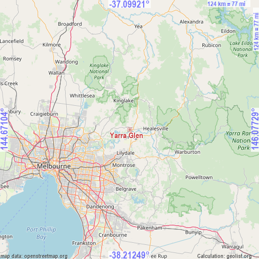
Yarra Glen GPS coordinates[2]
37° 39' 28.584" South, 145° 22' 26.976" East
| Map corner | latitude | longitude |
|---|---|---|
| Upper-left | -37.09921°, | 144.67104° |
| Center: | -37.65794°, | 145.37416° |
| Lower-right: | -38.21249°, | 146.07729° |
| Map W x H: | 123.8×123.8 km | = 76.9×76.9mi |
| max Lat: | -10.58257° ⇑84% North |
| Yarra Glen: | -37.65794° |
| min Lat: | ⇓16% South -43.31423° |
| min Long | Yarra Glen | max Long |
| 113.53327° | 145.37416° | 153.61246° |
| W 39.4%⇐ | ⇒60.6% E |
Elevation
Elevation of Yarra Glen is 79 m = 259 ft, and this is 43 m = 141 ft below average elevation for this country.
| Max E: |
1715 m = 5627 ft | 35.4% |
| Avg. | 122 m = 400 ft | |
| Yarra Glen | 79 m = 259 ft | |
Min E: |
-2 m = -7 ft | 64.6% |
See also: Australia elevation on elevation.city.
Geographical zone
Yarra Glen is located in South temperate zone (between Tropic of Capricorn and the Antarctic Circle). Distance of this Southern Tropic circle is 1581.3 km =982.6 mi to North.| Distance of | km | miles | from Yarra Glen |
|---|---|---|---|
| Equator | 4187.2 | 2601.8 | to North |
| Tropic Capricorn | 1581.3 | 982.6 | to North |
| Antarctic Circle | 3214 | 1997.1 | to South |
| South Pole | 5819.9 | 3616.3 | to South |


Nearby cities:
15 places around Yarra Glen: (largest is in red/bold)
• Badger Creek
13.4 km =8.3 mi,  110°
110°
• Chirnside Park
10.4 km =6.5 mi,  210°
210°
• Chum Creek
11.6 km =7.2 mi,  59°
59°
• Coldstream
7.5 km =4.7 mi,  177°
177°
• Cottles Bridge
14.4 km =8.9 mi,  293°
293°
• Croydon North
14.2 km =8.8 mi, 211°
• Gruyere
10.7 km =6.6 mi,  141°
141°
• Healesville
12.6 km =7.8 mi,  87°
87°
• Kangaroo Ground
13 km =8.1 mi,  254°
254°
• Kinglake
14.2 km =8.8 mi,  347°
347°
• Lilydale
10.5 km =6.5 mi,  191°
191°
• Mount Evelyn
14 km =8.7 mi, 176°
• Panton Hill
12 km =7.5 mi,  279°
279°
• Saint Andrews
10.9 km =6.8 mi,  304°
304°
• Wonga Park
12.6 km =7.8 mi,  228°
228°
Sources, notices
• [Note1] Compared only with cities in Australia existing in our database
• [Src1] Map data: © OpenStreetMap contributors (CC-BY-SA)
• [Src2] Other city data from geonames.org with taken over terms of usage.
• [Src3] Geographical zone / Annual Mean Temperature by Robert A. Rohde @ Wikipedia
