Chum Creek geodata
Chum Creek (Victoria) is a section of populated place; located in Australia in Australia/Melbourne (GMT+11) time zone. With population of 962 people, there are 3878 cities with bigger population in this country. Compared to other cities in Australia, 83.6% of cities are located further ↑North; 59.7% of cities are located further →East and 80.1% of cities have lower elevation than Chum Creek. Note1


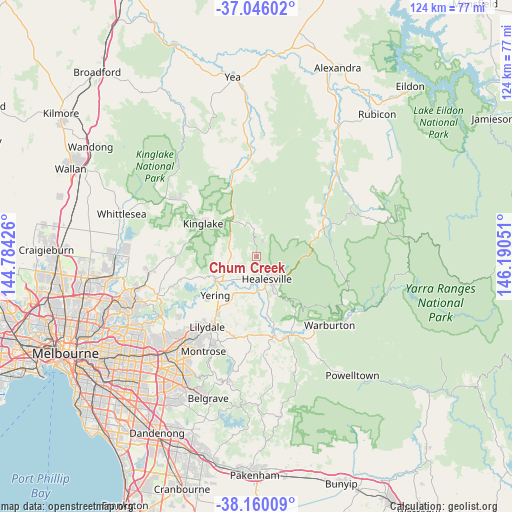
Chum Creek GPS coordinates[2]
37° 36' 18.504" South, 145° 29' 14.568" East
| Map corner | latitude | longitude |
|---|---|---|
| Upper-left | -37.04602°, | 144.78426° |
| Center: | -37.60514°, | 145.48738° |
| Lower-right: | -38.16009°, | 146.19051° |
| Map W x H: | 123.9×123.9 km | = 77×77mi |
| max Lat: | -10.58257° ⇑83.6% North |
| Chum Creek: | -37.60514° |
| min Lat: | ⇓16.4% South -43.31423° |
| min Long | Chum Creek | max Long |
| 113.53327° | 145.48738° | 153.61246° |
| W 40.3%⇐ | ⇒59.7% E |
Elevation
Elevation of Chum Creek is 182 m = 597 ft, and this is 60 m = 197 ft above average elevation for this country.
| Max E: |
1715 m = 5627 ft | 19.9% |
| Chum Creek | 182 m 597 ft | |
| Avg. | 122 m = 400 ft | |
Min E: |
-2 m = -7 ft | 80.1% |
See also: Australia elevation on elevation.city.
Geographical zone
Chum Creek is located in South temperate zone (between Tropic of Capricorn and the Antarctic Circle). Distance of this Southern Tropic circle is 1575.4 km =978.9 mi to North.| Distance of | km | miles | from Chum Creek |
|---|---|---|---|
| Equator | 4181.3 | 2598.1 | to North |
| Tropic Capricorn | 1575.4 | 978.9 | to North |
| Antarctic Circle | 3219.9 | 2000.8 | to South |
| South Pole | 5825.8 | 3620 | to South |


Nearby cities:
15 places around Chum Creek: (largest is in red/bold)
• Badger Creek
10.9 km =6.8 mi,  166°
166°
• Chirnside Park
21.3 km =13.2 mi,  225°
225°
• Coldstream
16.4 km =10.2 mi,  215°
215°
• Don Valley
17.3 km =10.7 mi,  147°
147°
• Gruyere
14.6 km =9.1 mi,  192°
192°
• Healesville
6 km =3.7 mi, 154°
• Kinglake
15.3 km =9.5 mi,  301°
301°
• Launching Place
20.8 km =12.9 mi,  159°
159°
• Lilydale
20.1 km =12.5 mi, 216°
• Saint Andrews
18.9 km =11.7 mi,  271°
271°
• Seville
21.4 km =13.3 mi,  179°
179°
• Seville East
18.9 km =11.7 mi, 177°
• Wandin North
20.4 km =12.7 mi, 193°
• Woori Yallock
20 km =12.4 mi, 167°
• Yarra Glen
11.6 km =7.2 mi,  239°
239°
Sources, notices
• [Note1] Compared only with cities in Australia existing in our database
• [Src1] Map data: © OpenStreetMap contributors (CC-BY-SA)
• [Src2] Other city data from geonames.org with taken over terms of usage.
• [Src3] Geographical zone / Annual Mean Temperature by Robert A. Rohde @ Wikipedia
