Gruyere geodata
Gruyere (Victoria) is a section of populated place; located in Australia in Australia/Melbourne (GMT+11) time zone. With population of 931 people, there are 3928 cities with bigger population in this country. Compared to other cities in Australia, 85.6% of cities are located further ↑North; 60% of cities are located further →East and 75.4% of cities have lower elevation than Gruyere. Note1


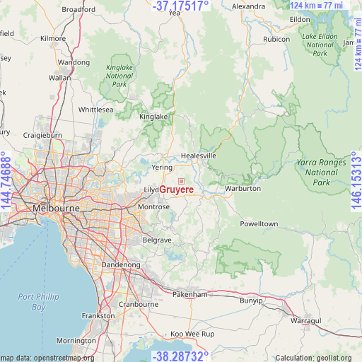
Gruyere GPS coordinates[2]
37° 43' 59.988" South, 145° 27' 0" East
| Map corner | latitude | longitude |
|---|---|---|
| Upper-left | -37.17517°, | 144.74688° |
| Center: | -37.73333°, | 145.45° |
| Lower-right: | -38.28732°, | 146.15313° |
| Map W x H: | 123.7×123.7 km | = 76.9×76.9mi |
| max Lat: | -10.58257° ⇑85.6% North |
| Gruyere: | -37.73333° |
| min Lat: | ⇓14.4% South -43.31423° |
| min Long | Gruyere | max Long |
| 113.53327° | 145.45° | 153.61246° |
| W 40%⇐ | ⇒60% E |
Elevation
Elevation of Gruyere is 135 m = 443 ft, and this is 13 m = 43 ft above average elevation for this country.
| Max E: |
1715 m = 5627 ft | 24.6% |
| Gruyere | 135 m 443 ft | |
| Avg. | 122 m = 400 ft | |
Min E: |
-2 m = -7 ft | 75.4% |
See also: Australia elevation on elevation.city.
Geographical zone
Gruyere is located in South temperate zone (between Tropic of Capricorn and the Antarctic Circle). Distance of this Southern Tropic circle is 1589.6 km =987.7 mi to North.| Distance of | km | miles | from Gruyere |
|---|---|---|---|
| Equator | 4195.6 | 2607 | to North |
| Tropic Capricorn | 1589.6 | 987.7 | to North |
| Antarctic Circle | 3205.6 | 1991.9 | to South |
| South Pole | 5811.5 | 3611.1 | to South |


Nearby cities:
15 places around Gruyere: (largest is in red/bold)
• Badger Creek
6.9 km =4.3 mi,  57°
57°
• Chirnside Park
11.9 km =7.4 mi,  267°
267°
• Coldstream
6.4 km =4 mi,  278°
278°
• Don Valley
12.5 km =7.8 mi,  91°
91°
• Healesville
10.6 km =6.6 mi,  33°
33°
• Kalorama
11.8 km =7.3 mi,  218°
218°
• Launching Place
11.7 km =7.3 mi,  116°
116°
• Lilydale
9 km =5.6 mi,  258°
258°
• Mount Evelyn
8.1 km =5 mi,  226°
226°
• Seville
7.9 km =4.9 mi,  155°
155°
• Seville East
6.2 km =3.9 mi,  138°
138°
• Silvan
9.7 km =6 mi,  197°
197°
• Wandin North
5.7 km =3.5 mi,  194°
194°
• Woori Yallock
9.4 km =5.8 mi, 124°
• Yarra Glen
10.7 km =6.6 mi,  321°
321°
Sources, notices
• [Note1] Compared only with cities in Australia existing in our database
• [Src1] Map data: © OpenStreetMap contributors (CC-BY-SA)
• [Src2] Other city data from geonames.org with taken over terms of usage.
• [Src3] Geographical zone / Annual Mean Temperature by Robert A. Rohde @ Wikipedia
