Kinglake geodata
Kinglake (Victoria) is a populated place; located in Australia in Australia/Melbourne (GMT+11) time zone. With population of 1,485 people, there are 3292 cities with bigger population in this country. Compared to other cities in Australia, 82.7% of cities are located further ↑North; 61% of cities are located further →East and 94.1% of cities have lower elevation than Kinglake. Note1


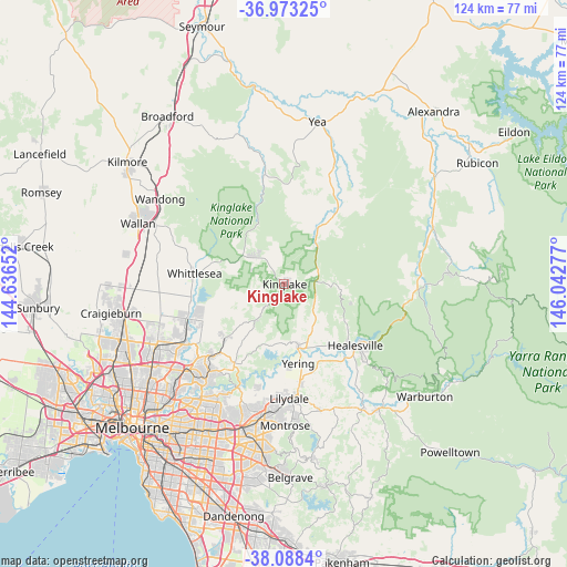
Kinglake GPS coordinates[2]
37° 31' 58.476" South, 145° 20' 22.704" East
| Map corner | latitude | longitude |
|---|---|---|
| Upper-left | -36.97325°, | 144.63652° |
| Center: | -37.53291°, | 145.33964° |
| Lower-right: | -38.0884°, | 146.04277° |
| Map W x H: | 124×124 km | = 77.1×77.1mi |
| max Lat: | -10.58257° ⇑82.7% North |
| Kinglake: | -37.53291° |
| min Lat: | ⇓17.3% South -43.31423° |
| min Long | Kinglake | max Long |
| 113.53327° | 145.33964° | 153.61246° |
| W 39%⇐ | ⇒61% E |
Elevation
Elevation of Kinglake is 548 m = 1798 ft, and this is 426 m = 1398 ft above average elevation for this country.
| Max E: |
1715 m = 5627 ft | 5.9% |
| Kinglake | 548 m 1798 ft | |
| Avg. | 122 m = 400 ft | |
Min E: |
-2 m = -7 ft | 94.1% |
See also: Australia elevation on elevation.city.
Geographical zone
Kinglake is located in South temperate zone (between Tropic of Capricorn and the Antarctic Circle). Distance of this Southern Tropic circle is 1567.3 km =973.9 mi to North.| Distance of | km | miles | from Kinglake |
|---|---|---|---|
| Equator | 4173.3 | 2593.2 | to North |
| Tropic Capricorn | 1567.3 | 973.9 | to North |
| Antarctic Circle | 3227.9 | 2005.7 | to South |
| South Pole | 5833.8 | 3625 | to South |


Nearby cities:
15 places around Kinglake: (largest is in red/bold)
• Chum Creek
15.3 km =9.5 mi,  121°
121°
• Coldstream
21.6 km =13.4 mi,  170°
170°
• Cottles Bridge
13.2 km =8.2 mi,  231°
231°
• Doreen
18.3 km =11.4 mi,  245°
245°
• Flowerdale
22.2 km =13.8 mi,  358°
358°
• Healesville
20.6 km =12.8 mi,  130°
130°
• Hurstbridge
17.6 km =10.9 mi, 226°
• Kangaroo Ground
19.8 km =12.3 mi,  208°
208°
• Kinglake West
11.9 km =7.4 mi,  308°
308°
• Panton Hill
14.9 km =9.3 mi,  216°
216°
• Saint Andrews
9.7 km =6 mi, 217°
• Wattleglen
20.3 km =12.6 mi, 222°
• Whittlesea
19.7 km =12.2 mi,  276°
276°
• Yarra Glen
14.2 km =8.8 mi, 167°
• Yarrambat
21.5 km =13.4 mi,  237°
237°
Sources, notices
• [Note1] Compared only with cities in Australia existing in our database
• [Src1] Map data: © OpenStreetMap contributors (CC-BY-SA)
• [Src2] Other city data from geonames.org with taken over terms of usage.
• [Src3] Geographical zone / Annual Mean Temperature by Robert A. Rohde @ Wikipedia
