Wynnum geodata
Wynnum (Queensland) is a section of populated place; located in Australia in Australia/Brisbane (GMT+10) time zone. With population of 12,650 people, there are 373 cities with bigger population in this country. Compared to other cities in Australia, 83.1% of cities are located further ↓South; 96.2% of cities are located further ←West and 62.8% of cities have higher elevation than Wynnum. Note1


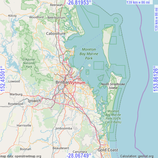
Wynnum GPS coordinates[2]
27° 26' 42.972" South, 153° 9' 29.268" East
| Map corner | latitude | longitude |
|---|---|---|
| Upper-left | -26.81953°, | 152.45501° |
| Center: | -27.44527°, | 153.15813° |
| Lower-right: | -28.06749°, | 153.86126° |
| Map W x H: | 138.8×138.8 km | = 86.2×86.2mi |
| max Lat: | -10.58257° ⇑16.9% North |
| Wynnum: | -27.44527° |
| min Lat: | ⇓83.1% South -43.31423° |
| min Long | Wynnum | max Long |
| 113.53327° | 153.15813° | 153.61246° |
| W 96.2%⇐ | ⇒3.8% E |
Elevation
Elevation of Wynnum is 29 m = 95 ft, and this is 93 m = 305 ft below average elevation for this country.
| Max E: |
1715 m = 5627 ft | 62.8% |
| Avg. | 122 m = 400 ft | |
| Wynnum | 29 m = 95 ft | |
Min E: |
-2 m = -7 ft | 37.2% |
See also: Australia elevation on elevation.city.
Geographical zone
Wynnum is located in South temperate zone (between Tropic of Capricorn and the Antarctic Circle). Distance of this Southern Tropic circle is 445.7 km =276.9 mi to North.| Distance of | km | miles | from Wynnum |
|---|---|---|---|
| Equator | 3051.6 | 1896.2 | to North |
| Tropic Capricorn | 445.7 | 276.9 | to North |
| Antarctic Circle | 4349.5 | 2702.7 | to South |
| South Pole | 6955.4 | 4321.9 | to South |


Nearby cities:
15 places around Wynnum: (largest is in red/bold)
• Belmont
6.4 km =4 mi,  201°
201°
• Birkdale
7.2 km =4.5 mi,  126°
126°
• Cannon Hill
6.9 km =4.3 mi,  244°
244°
• Carindale
8.7 km =5.4 mi,  219°
219°
• Chandler
7.7 km =4.8 mi,  186°
186°
• Gumdale
5.2 km =3.2 mi, 185°
• Hemmant
2.6 km =1.6 mi,  263°
263°
• Lota
3.8 km =2.4 mi, 134°
• Manly West
3.3 km =2.1 mi,  165°
165°
• Morningside
8.4 km =5.2 mi, 257°
• Murarrie
6.2 km =3.9 mi,  251°
251°
• Thorneside
6.2 km =3.9 mi,  140°
140°
• Tingalpa
4.4 km =2.7 mi, 224°
• Wakerley
4.2 km =2.6 mi,  183°
183°
• Wynnum West
1.5 km =0.9 mi, 198°
Sources, notices
• [Note1] Compared only with cities in Australia existing in our database
• [Src1] Map data: © OpenStreetMap contributors (CC-BY-SA)
• [Src2] Other city data from geonames.org with taken over terms of usage.
• [Src3] Geographical zone / Annual Mean Temperature by Robert A. Rohde @ Wikipedia
