Belmont geodata
Belmont (Queensland) is a section of populated place; located in Australia in Australia/Brisbane (GMT+10) time zone. With population of 3,648 people, there are 1937 cities with bigger population in this country. Compared to other cities in Australia, 82% of cities are located further ↓South; 95.8% of cities are located further ←West and 93.8% of cities have higher elevation than Belmont. Note1


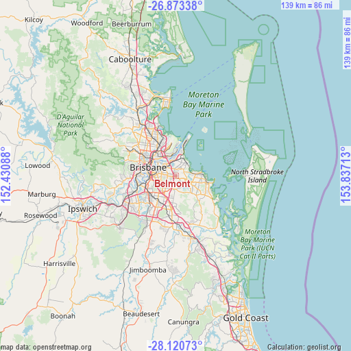
Belmont GPS coordinates[2]
27° 29' 55.752" South, 153° 8' 2.4" East
| Map corner | latitude | longitude |
|---|---|---|
| Upper-left | -26.87338°, | 152.43088° |
| Center: | -27.49882°, | 153.134° |
| Lower-right: | -28.12073°, | 153.83713° |
| Map W x H: | 138.7×138.7 km | = 86.2×86.2mi |
| max Lat: | -10.58257° ⇑18% North |
| Belmont: | -27.49882° |
| min Lat: | ⇓82% South -43.31423° |
| min Long | Belmont | max Long |
| 113.53327° | 153.134° | 153.61246° |
| W 95.8%⇐ | ⇒4.2% E |
Elevation
Elevation of Belmont is 7 m = 23 ft, and this is 115 m = 377 ft below average elevation for this country.
| Max E: |
1715 m = 5627 ft | 93.8% |
| Avg. | 122 m = 400 ft | |
| Belmont | 7 m = 23 ft | |
Min E: |
-2 m = -7 ft | 6.2% |
See also: Australia elevation on elevation.city.
Geographical zone
Belmont is located in South temperate zone (between Tropic of Capricorn and the Antarctic Circle). Distance of this Southern Tropic circle is 451.7 km =280.7 mi to North.| Distance of | km | miles | from Belmont |
|---|---|---|---|
| Equator | 3057.6 | 1899.9 | to North |
| Tropic Capricorn | 451.7 | 280.7 | to North |
| Antarctic Circle | 4343.6 | 2699 | to South |
| South Pole | 6949.5 | 4318.2 | to South |


Nearby cities:
15 places around Belmont: (largest is in red/bold)
• Camp Hill
5.7 km =3.5 mi,  275°
275°
• Cannon Hill
4.9 km =3 mi,  307°
307°
• Carina Heights
4.3 km =2.7 mi,  257°
257°
• Carindale
3.2 km =2 mi, 256°
• Chandler
2.2 km =1.4 mi,  138°
138°
• Gumdale
2 km =1.2 mi,  67°
67°
• Hemmant
5.7 km =3.5 mi,  357°
357°
• Lota
6.1 km =3.8 mi,  57°
57°
• Mackenzie
5.1 km =3.2 mi,  194°
194°
• Manly West
4.2 km =2.6 mi,  48°
48°
• Mansfield
5.7 km =3.5 mi,  217°
217°
• Murarrie
5.3 km =3.3 mi,  318°
318°
• Tingalpa
2.9 km =1.8 mi,  346°
346°
• Wakerley
2.8 km =1.7 mi, 50°
• Wynnum West
4.9 km =3 mi,  22°
22°
Sources, notices
• [Note1] Compared only with cities in Australia existing in our database
• [Src1] Map data: © OpenStreetMap contributors (CC-BY-SA)
• [Src2] Other city data from geonames.org with taken over terms of usage.
• [Src3] Geographical zone / Annual Mean Temperature by Robert A. Rohde @ Wikipedia
