Chandler geodata
Chandler (Queensland) is a section of populated place; located in Australia in Australia/Brisbane (GMT+10) time zone. With population of 1,409 people, there are 3357 cities with bigger population in this country. Compared to other cities in Australia, 81.7% of cities are located further ↓South; 96% of cities are located further ←West and 62.8% of cities have higher elevation than Chandler. Note1


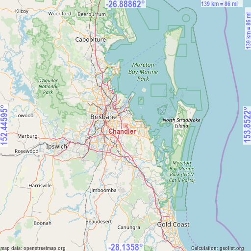
Chandler GPS coordinates[2]
27° 30' 50.328" South, 153° 8' 56.652" East
| Map corner | latitude | longitude |
|---|---|---|
| Upper-left | -26.88862°, | 152.44595° |
| Center: | -27.51398°, | 153.14907° |
| Lower-right: | -28.1358°, | 153.8522° |
| Map W x H: | 138.7×138.7 km | = 86.2×86.2mi |
| max Lat: | -10.58257° ⇑18.3% North |
| Chandler: | -27.51398° |
| min Lat: | ⇓81.7% South -43.31423° |
| min Long | Chandler | max Long |
| 113.53327° | 153.14907° | 153.61246° |
| W 96%⇐ | ⇒4% E |
Elevation
Elevation of Chandler is 29 m = 95 ft, and this is 93 m = 305 ft below average elevation for this country.
| Max E: |
1715 m = 5627 ft | 62.8% |
| Avg. | 122 m = 400 ft | |
| Chandler | 29 m = 95 ft | |
Min E: |
-2 m = -7 ft | 37.2% |
See also: Australia elevation on elevation.city.
Geographical zone
Chandler is located in South temperate zone (between Tropic of Capricorn and the Antarctic Circle). Distance of this Southern Tropic circle is 453.3 km =281.7 mi to North.| Distance of | km | miles | from Chandler |
|---|---|---|---|
| Equator | 3059.3 | 1901 | to North |
| Tropic Capricorn | 453.3 | 281.7 | to North |
| Antarctic Circle | 4341.9 | 2697.9 | to South |
| South Pole | 6947.8 | 4317.2 | to South |


Nearby cities:
15 places around Chandler: (largest is in red/bold)
• Belmont
2.2 km =1.4 mi,  318°
318°
• Burbank
4.7 km =2.9 mi,  182°
182°
• Capalaba
6.2 km =3.9 mi,  121°
121°
• Carina Heights
5.8 km =3.6 mi,  277°
277°
• Carindale
4.7 km =2.9 mi, 281°
• Gumdale
2.5 km =1.6 mi,  9°
9°
• Lota
6.2 km =3.9 mi,  36°
36°
• Mackenzie
4.3 km =2.7 mi,  220°
220°
• Manly West
4.8 km =3 mi,  20°
20°
• Mansfield
5.7 km =3.5 mi,  240°
240°
• Rochedale
6.1 km =3.8 mi,  194°
194°
• Thorneside
5.7 km =3.5 mi,  58°
58°
• Tingalpa
5 km =3.1 mi,  334°
334°
• Wakerley
3.5 km =2.2 mi, 11°
• Wynnum West
6.2 km =3.9 mi,  3°
3°
Sources, notices
• [Note1] Compared only with cities in Australia existing in our database
• [Src1] Map data: © OpenStreetMap contributors (CC-BY-SA)
• [Src2] Other city data from geonames.org with taken over terms of usage.
• [Src3] Geographical zone / Annual Mean Temperature by Robert A. Rohde @ Wikipedia
