Winchelsea geodata
Winchelsea (Victoria) is a populated place; located in Australia in Australia/Melbourne (GMT+11) time zone. With population of 1,905 people, there are 2968 cities with bigger population in this country. Compared to other cities in Australia, 94.5% of cities are located further ↑North; 72.5% of cities are located further →East and 68.2% of cities have lower elevation than Winchelsea. Note1


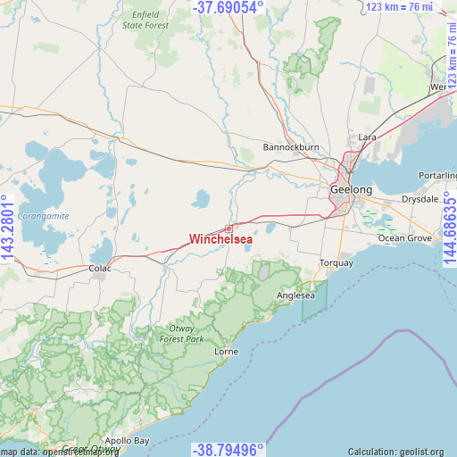
Winchelsea GPS coordinates[2]
38° 14' 41.46" South, 143° 58' 59.592" East
| Map corner | latitude | longitude |
|---|---|---|
| Upper-left | -37.69054°, | 143.2801° |
| Center: | -38.24485°, | 143.98322° |
| Lower-right: | -38.79496°, | 144.68635° |
| Map W x H: | 122.8×122.8 km | = 76.3×76.3mi |
| max Lat: | -10.58257° ⇑94.5% North |
| Winchelsea: | -38.24485° |
| min Lat: | ⇓5.5% South -43.31423° |
| min Long | Winchelsea | max Long |
| 113.53327° | 143.98322° | 153.61246° |
| W 27.5%⇐ | ⇒72.5% E |
Elevation
Elevation of Winchelsea is 93 m = 305 ft, and this is 29 m = 95 ft below average elevation for this country.
| Max E: |
1715 m = 5627 ft | 31.8% |
| Avg. | 122 m = 400 ft | |
| Winchelsea | 93 m = 305 ft | |
Min E: |
-2 m = -7 ft | 68.2% |
See also: Australia elevation on elevation.city.
Geographical zone
Winchelsea is located in South temperate zone (between Tropic of Capricorn and the Antarctic Circle). Distance of this Southern Tropic circle is 1646.5 km =1023.1 mi to North.| Distance of | km | miles | from Winchelsea |
|---|---|---|---|
| Equator | 4252.4 | 2642.3 | to North |
| Tropic Capricorn | 1646.5 | 1023.1 | to North |
| Antarctic Circle | 3148.7 | 1956.5 | to South |
| South Pole | 5754.6 | 3575.7 | to South |


Nearby cities:
15 places around Winchelsea: (largest is in red/bold)
• Aireys Inlet
26.5 km =16.5 mi,  156°
156°
• Anglesea
25.3 km =15.7 mi,  135°
135°
• Bannockburn
27.2 km =16.9 mi,  36°
36°
• Batesford
31.2 km =19.4 mi,  55°
55°
• Bellbrae
26.6 km =16.5 mi,  111°
111°
• Birregurra
20.1 km =12.5 mi,  239°
239°
• Highton
29.8 km =18.5 mi,  73°
73°
• Inverleigh
17 km =10.6 mi,  20°
20°
• Jan Juc
29.4 km =18.3 mi, 112°
• Moriac
16.7 km =10.4 mi,  88°
88°
• Mount Duneed
30.9 km =19.2 mi, 89°
• Teesdale
24.2 km =15 mi,  13°
13°
• Torquay
31.4 km =19.5 mi, 107°
• Wandana Heights
29 km =18 mi, 74°
• Waurn Ponds
26.4 km =16.4 mi,  83°
83°
Sources, notices
• [Note1] Compared only with cities in Australia existing in our database
• [Src1] Map data: © OpenStreetMap contributors (CC-BY-SA)
• [Src2] Other city data from geonames.org with taken over terms of usage.
• [Src3] Geographical zone / Annual Mean Temperature by Robert A. Rohde @ Wikipedia
