Aireys Inlet geodata
Aireys Inlet (Victoria) is a populated place; located in Australia in Australia/Melbourne (GMT+11) time zone. With population of 802 people, there are 4142 cities with bigger population in this country. Compared to other cities in Australia, 95.8% of cities are located further ↑North; 72.3% of cities are located further →East and 83.5% of cities have higher elevation than Aireys Inlet. Note1


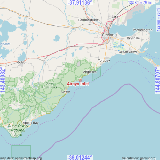
Aireys Inlet GPS coordinates[2]
38° 27' 50.4" South, 144° 6' 14.184" East
| Map corner | latitude | longitude |
|---|---|---|
| Upper-left | -37.91136°, | 143.40082° |
| Center: | -38.464°, | 144.10394° |
| Lower-right: | -39.01244°, | 144.80707° |
| Map W x H: | 122.4×122.4 km | = 76.1×76.1mi |
| max Lat: | -10.58257° ⇑95.8% North |
| Aireys Inlet: | -38.464° |
| min Lat: | ⇓4.2% South -43.31423° |
| min Long | Aireys Inlet | max Long |
| 113.53327° | 144.10394° | 153.61246° |
| W 27.7%⇐ | ⇒72.3% E |
Elevation
Elevation of Aireys Inlet is 13 m = 43 ft, and this is 109 m = 358 ft below average elevation for this country.
| Max E: |
1715 m = 5627 ft | 83.5% |
| Avg. | 122 m = 400 ft | |
| Aireys Inlet | 13 m = 43 ft | |
Min E: |
-2 m = -7 ft | 16.5% |
See also: Australia elevation on elevation.city.
Geographical zone
Aireys Inlet is located in South temperate zone (between Tropic of Capricorn and the Antarctic Circle). Distance of this Southern Tropic circle is 1670.9 km =1038.2 mi to North.| Distance of | km | miles | from Aireys Inlet |
|---|---|---|---|
| Equator | 4276.8 | 2657.5 | to North |
| Tropic Capricorn | 1670.9 | 1038.2 | to North |
| Antarctic Circle | 3124.4 | 1941.4 | to South |
| South Pole | 5730.3 | 3560.6 | to South |


Nearby cities:
15 places around Aireys Inlet: (largest is in red/bold)
• Anglesea
9.5 km =5.9 mi,  48°
48°
• Armstrong Creek
35 km =21.7 mi,  42°
42°
• Bellbrae
20.3 km =12.6 mi, 44°
• Birregurra
31.2 km =19.4 mi,  296°
296°
• Connewarre
33.9 km =21.1 mi, 49°
• Grovedale
36.4 km =22.6 mi, 36°
• Highton
37.3 km =23.2 mi,  29°
29°
• Jan Juc
21.3 km =13.2 mi, 51°
• Lorne
14 km =8.7 mi,  232°
232°
• Moriac
25.6 km =15.9 mi,  13°
13°
• Mount Duneed
32.1 km =19.9 mi, 39°
• Torquay
24.4 km =15.2 mi, 52°
• Wandana Heights
36.5 km =22.7 mi, 28°
• Waurn Ponds
31.6 km =19.6 mi, 29°
• Winchelsea
26.5 km =16.5 mi,  336°
336°
Sources, notices
• [Note1] Compared only with cities in Australia existing in our database
• [Src1] Map data: © OpenStreetMap contributors (CC-BY-SA)
• [Src2] Other city data from geonames.org with taken over terms of usage.
• [Src3] Geographical zone / Annual Mean Temperature by Robert A. Rohde @ Wikipedia
